Tuesday, January 31, 2006

Platial

Good Morning! I have a demo on a TopCon GPS unit this afternoon. If you have any experience with this company or its' products please give me some feedback. ESRI released some big news yesterday. They announced ArcWeb Explorer Beta. I've taken it for a spin and I'm not impressed. I hope they do some major work on it. They also announced that you can now sign up for the annual user conference that will be in August. Have a good day!

Platial enables anyone to find, create and use meaningful maps of Places that matter to them. They hope it can connect people, neighborhoods, cities and countries through a citizen-driven common context that goes beyond geopolitical boundaries. It's similar to other Google Mashups and has a nice look and feel to it. Check it out at www.platial.com.

Monday, January 30, 2006

Penn State Online Masters in GIS

Good Morning! My weekend was nice. We got a little rain, had a bike ride and caught up on sleep. That's what weekends are all about! Just a reminder that the 16th annual South Central Arc User Group conference is next week in Fort Worth. If you are in Texas, Oklahoma, Louisiana, or Mississippi you should try to attend. It's going to be a blast! If you are not in one of those states you should also try to attend. Why not?

Penn State Univeristy offers an online masters program in GIS. The Master of Geographic Information Systems (MGIS) degree program is designed to give working professionals, who are aspiring to leadership positions in the field, an opportunity to pursue a world-class master's degree online. This 35-credit curriculum allows you to study around your own schedule, where and when it's most convenient for you. I know what you are thinking about this being an online program, but it looks pretty thorough. Check it out at http://www.worldcampus.psu.edu/wc/MasterinGIS_GIS.shtml .

Friday, January 27, 2006

LocaPoint DIY Map Service

Happy Friday! I have no big plans this weekend, which I am excited about. I do have to go out and learn how to use a new Leica GPS unit. My girlfriend will be using it in Mexico this spring for her thesis research so we need to learn how to use it. I am familiar with Trimble units and I hear that the Leica units are quite different. Wish me luck!!

LocaPoint has a DIY map service that allows you to create your own map. You can add lines and markers then all the data about your 'DIY Map' will be packed into URL string, so it is easy to send it via email, etc. It uses Google maps to provide this free service. Check it out at http://www.locapoint.com/en/diymapHome.html.

Thursday, January 26, 2006

BatchGeocode

The service pack install went more smoothly than anticipated. Some of the instructions on the ArcIMS install were a little shaky, but we figured it out. They keep saying that installation will be much easier with the realease of ArcIMS 9.2. I sure hope so!! It feels like ArcIMS is open source software during the install process because of all of the different pieces that have to be installed and work together. I would like one CD that I drop in the drive and push the install button for $8K!!

Geocoding on the web is not a new concept, in fact there are many free geocoders available on the web, but BatchGeocode is the first free browser based geocoding service to provide coordinate lookup in bulk form. Now you can take many addresses and geocode them all at once, rather than one at a time. BatchGeocode.com also provides a more accurate geocoding dataset than others, most of which use TIGER data, which is known to be inaccurate up to several hundred feet in some areas. Yahoo's Geocoding API which this site uses is based on NAVTEQ (formally NAVTECH) and Tele Atlas street data, both well known as industry standards for transportation data. You can use BatchGeocode to:
- Geocode a contact address list directly from spreadsheet program such as Excel.
- Create lat/long coordinates for use in an online Mapping program such as Yahoo Maps or Google Maps.
- Quickly visualize your information on a map.
- Import/export from a SQL database coordinates for usage in a GIS application.
- Quickly map a set of real-estate properties for a presentation.
- Get centroids (center coordinates) for a listing of zipcodes, cities, or states.
- For quick single address, zipcode, city or state geocodes use our Single Address Lookup Tool
Check it out at www.batchgeocode.com !!

Wednesday, January 25, 2006

AuctionMapper

Happy Wednesday! We are installing the service pack that ESRI put out for SDE, IMS and ArcGIS desktop this evening. I haven't heard of anyone having difficulties with this, but just in case wish us luck. If you have any feedback about it let me know.

AuctionMapper is a cool site that I found that combines mapping with eBay items. Although according to AuctionMapper it is somewhat different from using a typical search engine and it does much more than place eBay items on a map. AuctionMapper is designed to help you find exactly what you want in the shortest amount of time; therefore it gives you search results without having to go from web page to web page. Think of AuctionMapper as a deluxe search tool that allows you to quickly filter your searches down precisely to what you are looking for. The filtered searches are then presented either in a list view or on a map depending on how you choose to view the results. Unlike a typical advanced search where you have to keep going back and forth between the advanced search page and the results page to tweek various constraints, AuctionMapper stays on one page while only the results change, making adjustments to the constraints painless. If you are looking for something big that would be difficult to ship or that you would not want to bid on without seeing first then the map is a great way to locate items for serious consideration. You can easily map the 25 nearest items by dragging a category to the map. You can also map the most or least expensive items as well as by when the item was listed. There are sliders above the map that dynamically display items on the map based on various criteria such a price, number of bids, ending time, and distance. On the other hand AuctionMapper is also a great way to narrow down your searches for items for which location is irrelevant. There are Item Finders that help you locate specific items quickly. The Category Tree lets you see which categories contain your search term. The Item List lets you sort and resort your search results quickly based on price, number of bids, and ending time. You can also select items from the list to display on the map once you find items of real interest and want to see where they are. A pretty handy tool if you are a big eBay shopper. Check it out at www.auctionmapper.com .

Tuesday, January 24, 2006

Panoramio

Wow was it foggy here this morning! It took me almost 1.5 hours to get to work instead of my usual 1.25. Anyway, I have a couple of meetings to run to. One is the Supervisors Network. This is a program we do here at the City that helps new supervisors become better supervisors. This is our first meeting and I am looking forward to it. Our assignment was to read an excellent article from the October 2005 U.S. News and World Report about the countries best leaders. You should check it out if you have time. Have a great day!!

Every photo is linked with the place where it was taken, both physically and in your memory. Panoramio helps to link photos and places. For your photos: Never forget the name and location of the small village you visited in Bolivia. Remember the trail you walked to climb that peak in Cuba. You can share photos of your city, your business or your friends with everybody. For virtual travelling: You can explore how the place you are interested in really looks. These are not postcard photos, but photos taken by random people. Panoramio is works well and is free. Check out this Google Mashup at www.panoramio.com.

Monday, January 23, 2006

Environmental Information Systems of Africa

Happy Monday! I had a good weekend. We had a few cold beverages with friends on Friday night, got all of our errands done on Saturday and cleaned the entire house on Sunday. That's much more productive than normal!!

I was looking at the ClustrMaps map on the bottom right of the page and I noticed that no one from Africa has viewed the blog. So I did a little research. The only GIS related websites I could come up with were from South Africa including the Environmental Information Systems (EIS) of Africa page. Just think of the help that GIS could provide if it is eventually used throughout Africa. The creation of EIS-AFRICA consolidated ten years of investment and capacity building efforts in Environmental Information Systems (EIS) in sub-Saharan Africa into an Africa-wide organization promoting the greater use of harmonised geo-spatial information. EIS-AFRICA is a non-profit pan-African organization of geo-information practitioners and institutions. It is based in Pretoria, South Africa, and is recognized by their strategic partners, clients and the public as a leading organization developing African capacity to generate, manage, disseminate and use geo-spatial and environmental information to enrich policy debate and support decision-making for the well-being of African people. Check it out at http://www.eis-africa.org/EIS-Africa .

Friday, January 20, 2006

MapTools.org

Better late than never! It has been a busy morning here at the City. Three meetings before 11:30. It must mean that business is good! I know I mentioned it last month, but we had another GIS User Committee meeting today. This is an excellent venue to discuss tools, share status of projects, discuss problems, etc. Think about it if you don't already do this. You will not be sorry! Have a most excellent weekend!!!

MapTool.org is a resource for users and developers in the open source mapping community, and a home to many open source projects. The projects that are hosted here offer essential services including: latest downloads, CVS repositories for source code, bug lists, community mailing lists, and project documentation. You can even buy a MapTools t-shirt. Check it out at www.maptools.org if you are ready to tackle your own open source map project.

Thursday, January 19, 2006

Global Connection

Our new Technician has employee orientation today here at the City. This is a day of tours, policies and personality testing. It is extremely helpful to new employees and can be a fun experience. This may be something to consider at your organization.

Global Connection is a joint project of Google, National Geographic, NASA, and Carnegie Mellon University. The project's long-term goal is to help people learn about and meet our neighbors across this globe, and learn about our planet itself. When astronauts go into space, they develop a new appreciation for the oneness of the Earth. Global Connection is working with the earth-imaging browser Google Earth and populating it with pictures and stories of real people and places to create connectivity. Their motto is "This world is our home, and all people are our family". The project is supported through the generosity of Google and the National Geographic Society. Learn more about the things they are doing at http://www.cs.cmu.edu/~globalconn/.

Wednesday, January 18, 2006

Virtual NYC Tour

Good Morning! I can't believe it is already Wednesday. This week is flying by! I have a day without meetings and I hope to get alot accomplished. Keep your fingers crossed for me.

The Virtual NYC Tour is a great Google Mashup. Like never before, you can navigate through the streets of New York while viewing thousands of pictures, visiting hundreds of stores and reading the city’s famous history. You can select a number of trails on the maps to start your virtual tour of New York City. You can view and virtually visit Central Park, Times Square, Fifth Avenue, the Empire State Building and many more. Enjoy the tour at www.virtualnyctour.com.

Tuesday, January 17, 2006

GIS Development

Welcome back to those of us that were fortunate enough to have yesterday off to honor the great Dr. King. If you have never heard Dr. King's famous 'I Have A Dream' speech you should listen. I enjoyed the weekend with friends enjoying the beautiful Texas weather and the great outdoors. I must camp more this year!! Have a great week!!

GIS Development strives to promote and propagate the usage of Geographic Information Science, Technology and Applications in various areas of development, worldwide and Asia in particular. It assists community and government in developing their productivity, policies and management capabilities by facilitating knowledge transfer in the domain of geographic information. It fosters the growing network of those interested in geo-informatics and encourages the exchange of scientific know-how through its key platforms: Magazines, Portal, Conferences and Training. Check it out at www.gisdevelopment.net.

Friday, January 13, 2006

map builder

It's Friday!! I'm going camping this weekend and hopefully I won't freeze to death. It's supposed to be in the low 40's at night so that shouldn't be too bad. I heard a great story on NPR yesterday about Google Map Mashups. You can read and listen to it at http://www.npr.org/templates/story/story.php?storyId=5151938. Have a great weekend!!

MapBuilder.net is an Web2.0 service that is used to build custom Google and Yahoo maps without any knowledge of the Google/Yahoo Maps API and JavaScript. MapBuilder provides a decent visual interface for the map building process with geocoding features. Also MapBuilder lets users tag locations on their maps, and then publish the map either on MapBuilder.net or their own website. Check it out at www.mapbuilder.net.

Thursday, January 12, 2006

GIS Monitor

The presentation to the high school students went OK. I only put half of them to sleep. Ha! Today I am giving the same presentation four times in a row to an adult crowd. We will see if my results are the same. I also have training in the afternoon for "Time Management". I think we can all use help with that one.

The GIS Monitor helps you stay informed by providing a weekly newletter, articles, events, education, data, reference information and jobs. By subscribing to the GIS Monitor, the industry's most insightful newsletter it will be delivered every Thursday, free of charge. The GIS Monitor newsletter includes: • product announcements and updates• expert analysis and insight• industry events• business news: mergers, acquisitions, partnerships• big sales and contracts• financial information• key management changes. Check it out at www.gismonitor.com.

Wednesday, January 11, 2006

Quantum GIS

Howdy! Today is my presentation to 25 high school students. We will see if relating Geography to pop culture is an effective way of getting them interested in Geography and GIS. Hopefully they will leave with a firm understanding of what GIS is and how it is used at the City. I also hope that it excites some of them about the profession! I'll keep you posted.

Quantum GIS (QGIS) is a user friendly Open Source Geographic Information System (GIS) that runs on Linux, Unix, Mac OSX, and Windows. QGIS supports vector, raster, and database formats. QGIS is licensed under the GNU Public License. Some of the major features include: Support for spatially enabled PostGIS tables; Support for shapefiles, ArcInfo coverages, Mapinfo, and other formats supported by OGR; Raster support for a large number of formats; Identify features; Display attribute tables; Select features; GRASS Digitizing; Feature labeling. You can find all you need to know at http://www.qgis.org.

Tuesday, January 10, 2006

Flash Earth


Good Morning! I've got "When Employee Performance Takes a Nose-Dive" training this morning. This kind of training is often extremely useful even if it is a refresher. If your organization offers courses like this you should take advantage of them. I hope I pick up some new tips!

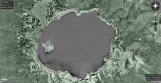
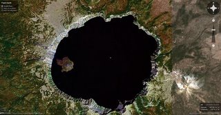
I've got a special treat today for all of you flash programmers. Flash Earth is a smoother version of Google Maps (on the bottom) and Microsoft Networks Virtual Earth (on the top) using Flash. As Paul Neave says "though I adore the smell of old ink and BO stained paper (old atlases), I wanted to make a digital map of the World". You get a sense of location because you can zoom in and out without the display being recreated. And you can rotate the map, something almost impossible to do using HTML and JavaScript (or AJAX if you know your web jargon), but easy with Flash. You can also link to a location anywhere. Check it out at http://www.flashearth.com/.

Monday, January 09, 2006

Common Census Map Project

What a great weekend.....the weather was incredible, the bike rides were awesome and the sleep was perfect. It doesn't get any better than that!! It is going to be another busy week. I have some training and five presentations to explain what GIS is and how it helps the City I work for.

The CommonCensus Map Project is redrawing the map of the United States based on your input, to reveal the boundaries people themselves feel, as opposed to the state and county boundaries drawn by politicians. View the maps to see how the country is divided into 'spheres of influence' between different cities at the national, regional, and local levels. This information will finally settle the question over exactly where cultural boundaries lie, contribute to the national debate over Congressional redistricting and gerrymandering, and educate people everywhere as to the true layout of the American people that they've never seen on any map before. You can even contribute your information for the map. Check it out at http://www.commoncensus.org/.

Friday, January 06, 2006

Mapdex

It's Friday and the Longhorns are still the National Champions!!! I hope to catch up on sleep and get a good bike ride in. It is supposed to be in the 70's all weekend (I love Texas!). It's also nice that the Holidays are over and we don't need to travel somewhere. I will also be working on a presentation for high school students and I am trying to tie Geography (GIS) to pop culture. If anyone has seen some examples of Geography or even better GIS in pop culture please send them my way. Have a great weekend!!

At the time of this post Mapdex had a near-global index of 1,781 servers, serving 32,433 map services, containing over 400,000 GIS Layers, covering more than 4,000,000 columns! Wow!! Mapdex is a first cut at creating an index of web mapping services. I did a quick search for streets in my semi-rural zip code and came up with 53 layers in 23 servers. Not bad!! You also have the ability to search by server, service, layer, column and even address. Check it out at www.mapdex.org.

Thursday, January 05, 2006

The University of Texas Department of Geography and the Environment

In-VINCE-able!!!! Need I say more? What a season and what a game! Good job Longhorns!! You are the National Champions of college football!!!! You made a fellow Austinite proud last night.

I felt it was only appropriate to talk about the University of Texas Department of Geography and the Environment today. For 55 years the Department of Geography and the Environment has provided multiple perspectives and tools to understand the relationships between people and their environments, analyze diverse cultural landscapes, and solve problems related to local and global change. The Department's faculty has had an outstanding record of research and publication; indeed, a recent survey in The Professional Geographer found the faculty's book publication productivity to be the highest of any geography department in the nation. The department offers the best undergraduate geography program in Texas according to Rugg's Recommendations on the Colleges. UT Geography offers an integrated approach to Geographic Information Science (GISc) research and teaching that provides technical skills while maintaining the institutional priority of quality research. GISc refers to the integration of two components: scientific theory and information systems. So if you are interested in furthering your education with a bachelors, masters or doctorate and want to live in a great City check out the University of Texas Department of Geography and the Environment at http://www.utexas.edu/cola/depts/geography/.

Wednesday, January 04, 2006

Google Ride Finder

Good Morning! It's Records Management Day here at the City. This day allows us time to go through our paper and electronic files and remove unneeded items. Hopefully, I will become better organized for the new year! It is extremely beneficial if your organization doesn't already have a similar program.

Are you looking for a ride to an airport, theater, party, store, work or any place else? Do you feel like finding the right company is a bit of a shot in the dark? Worried about getting picked up in a timely fashion or whether the company has vehicles in the area? With Google Ride Finder, you can search for taxis, limousines and shuttles and make better decisions by seeing the exact location of vehicles in your area. Just enter a zip code, the name of a city or even a specific address. You will get a map showing the companies and where their vehicles are located. For now, Ride Finder is a beta product which is only available in about 15 metro areas in the United States. As it is developed and improved the service, is planned to be expanded to locations throughout the U.S. and other parts of the world. This is a great example of how AVL can be used to help customers as well as companies. Check it out at http://labs.google.com/ridefinder.

Tuesday, January 03, 2006

Geograph

It's 2006!! I can't beleive we are already over half way to 2010. Time flies when you are having fun! We had a great New Year's Eve with family and friends. I hope that you did as well. May the new year bring you good health and happiness!!

The Geograph British Isles project aims to collect a geographically representative photograph for every square kilometre of the British Isles and you can be part of it. What is Geographing? It's a game - how many grid squares will you contribute?; It's a geography project for the people; It's a national photography project; It's a good excuse to get out more!; It's a free and open online community project for all. I have been told that a similar project exists for the U.S., but I can't find it. If you know what the project is called please let me know. You can find out more about the Geograph British Isles project at http://www.geograph.org.uk/.

Planet Geospatial

ESRI.com - News

GISUser.com - The complete GIS, LBS, and Geospatial Technology Resource

A VerySpatial Podcast