Sunday, May 06, 2007
New Website!
As most of you have noticed, I've discontinued my blog. It got to be too time consuming and I was really kinda getting bored with it. I hope to be starting something new soon. Once I have it up and running I will announce it here and then delete the GIS-Geoblog. I really do appreciate all of the positive feedback that I received from this experience. Thank you!
Wednesday, December 06, 2006
GIS in the Face of Tragedy
| The story of how GIS was used in the recovery of the space shuttle Columbia. | |
Monday, October 16, 2006
toEat

It's been a while! We have been busy as ever at work. Our focus has been on process flows and quality control for our data that we got back from our consultant. The time constraint has made me half way consider discontinuing the blog, at least for a while. I'll see how the next week goes and then decide. Have a good one!
"toEat.com aims to be the central point for hungry people and restaurants to congregate. Our first release, the restaurant browser system, is only a small piece of what is on the toEat.com roadmap. In the next 6 months we're going to be building up features to allow restaurant owners to manage their own Internet websites, online advertising portfolios, and interactive solutions for bringing more customers into their restaurants by effectively showing people what is available to them." Check it out at www.toeat.com.
Monday, October 09, 2006
Global Hotel Index
 Good morning! It's been a while since I posted last. Part of the reason is that I was at the Oklahoma SCAUG conference in Oklahoma City. I gave a presentation on the GIS Certification Institute and GIS certification. Also, as a SCAUG officer, wanted to show our support to the Oklahoma chapter. They are by far a model of what we want to create in all of our chapters. I didn't do much over the weekend, but work most of the day on Sunday. Today, we continue on our mission of mapping process flows for all 64 of our layers.
"Global Hotelindex Ltd, founded in Switzerland, is a privately held company focused on hotel search services and tourism related advertising." So what do they have to do with geospatial technology? Not much, but they have a really cool flash based map that is used to zoom into your area of interest. Check it out at http://www.globalhotelindex.com/.
Tuesday, October 03, 2006
Population Action International
 G'Day! Well, the GIS Specialist came back today. I didn't scare him off with the thought of doing process flows and quality control on 64 layers. Today, we have another GIS Day planning committee meeting. We will be discussing the "What is GIS" section of our event. This afternoon the GIS Specialist and myself will hopefully wrap up our discussion on current projects. Oh yeah, I forgot to mention that our GIS Technician got a new title with the new budget year. He is now the GIS Data Steward. I don't think he is too keen on the name, but it is fitting. Has anyone else heard or used this title?
 "How many people will live on the planet 20 years from now? Where will they live? Where will population grow, and where will it decline? The map on Population Action International page illustrates a projected possible answer to these questions, applying new methods of mapping population density and of projecting its future." Check it out at http://www.populationaction.org/resources/publications/mappingthefuture/index.htm.
Monday, October 02, 2006
National Geographic MapMachine
 Happy Monday! I've been slacking on making my posts again. Since I last posted I attended diversity training at the City. It was an excellent class and taught in a unique way. It was more fact based than "you should do this" or "you shouldn't do that". Hopefully it will help to improve some attitudes. Friday we got all of our data back from our consultant and it was loaded into the geodatabase. Now the big work starts of quality control. Today, our new GIS Specialist starts. We will be spending the majority of the day reviewing policies and work projects that need to be worked on immediately. I'm going to leave you today with a couple of quotes that I got from the diversity training that I think could help us all get along a little better. "Life, at its' best, is a creative synthesis of opposites in fruitful harmony" - Dr. Martin Luther King Jr. "You must be the change you wish to see in the World" - Gandhi.
The National Geographic MapMachine powered by ESRI allows you to locate nearly any place on Earth, find country facts, and search and print historical, weather, and population maps, and more with this dynamic atlas. Check it out at http://plasma.nationalgeographic.com/mapmachine/index.html.
Labels:
Diversity,
GIS Specialist,
MapMachine,
National Geographic
Wednesday, September 27, 2006
Free GIS Data & Imagery GeoBlog
 Evening! The second and final day of Intro to ArcGIS went smoothly. I even got an awesome crystal globe from one of my students. Too cool! I'm also working late again! It's hard to keep up with the day to day and teach. What am I complaining about? I love it!!
The GISUser, aka Glenn Letham, has a new blog out called the Free GIS Data & Imagery GeoBlog. This is Glenn's attempt at stopping folks from paying for public domain GIS data. It contains public domain GIS data and Free GIS data repositories and clearinghouses. As Glenn says, "Are you still paying commercial data resources for Free, public domain GIS data? If so STOP IT and WAKE UP! Are you looking for Free GIS data products like DRG, DEM, DLG, DOQQ, Census data, or ? Search no more!" Check it out at http://gisdata.blogspot.com/.
Tuesday, September 26, 2006
World66
 Nî hâo! I'm teaching Intro to ArcGIS today. So far we haven't had any major glitches (with people or computers). I'm getting excited because we are getting our data back from our consultant this Thursday. They will be loading it into SDE and then we will be ready for quality control. Too cool!
"Let's start with their credo: We believe that travelers are the best source of travel information. World66 is an open content travel guide, where people from all over the planet can write about the places they love, the hotels they stayed in, the restaurants that have eaten. Every part of the travel guide can be edited directly, just click the [edit] button and go ahead. You can change the info you find, do a write up, add a complete city or just a bar or a restaurant. Thanks to this approach World66.com has become one of the most complete travel resources on the internet, with 94,510 articles on 34,732 destinations all over the world. Good info, more up to date than you find in travel books. Check for yourself. And should you find some wrong info, a hotel that has closed down, whatever, don't complain, but act. You can change it. It's up to you." You can also create maps to use on your blog or MySpace that show where you have traveled or where you want to travel. Check it out at http://www.world66.com/.
Monday, September 25, 2006
The Daily Render
 Guten Tag! As you might have noticed I missed another post on Friday! I have been such a slacker lately. This weekend I used our wares to help in the search for Brandi Wells, a missing woman here in town. It is interesting to see the inner workings of a major search effort like this. If you ever have the opportunity to help with something like this, please do so. You will be surprised to learn that the search organizations don't even know you exist, but will be very happy to have your help. I have many meetings today and I'm teaching Intro to ArcGIS tomorrow. Wish me luck!
Nikolas Schiller uses imagery to create what he calls geospatial art. The photo I have posted here is from Dallas, TX. From what I gather Nickolas is a Geography student at George Washington University, but his true love seems to be his art. He also is a strong proponent of the Green Party and the fact that our country is run by big business corporations. Check it out at http://nikolasschiller.com/blog/.
Thursday, September 21, 2006
Yes.com
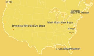
 Talofa! Does anyone know what that means? Anyway, another day down and it's almost Friday. I've actually been getting caught up on alot this week since I haven't had many meetings and the requests have been slow. I do have a few meetings tomorrow, but nothing major so the flow of productivity should continue. Be sure and take a look at the pics from the Austin City Limits Music Festival that I posted at the bottom of the page. The captions are courtesy of the girlfriend.
Yes.com, a website that covers the most listened to stations in the top 150 locations in the US, has created a "an online geographical visualization of the songs that are currently played on those stations in real time." It's pretty cool because you see the titles of the songs pop up all around the country on a Flash map. Check it out at http://www.yes.com/yesnation.swf.
Subscribe to:
Comments (Atom)


