Wednesday, September 20, 2006

Geospatial Industry Workforce Information System

Good evening! I got quite a bit accomplished today since I didn't have any meetings. Tomorrow will be the same. So, if you have been waiting on an email or phone call from me, tomorrow may be your lucky day. We are getting close to officially announcing the East Texas Geospatial Conference that is in the works for November. We are also making some progress with GIS Day. Oh yeah, we are also getting all of our data back next week from our consultant........too busy!!

"GIWIS, or the Geospatial Industry Workforce Information System, is the nation's first and only online geospatial workforce information network. Whether you’re a veteran to the geospatial industry or you've just heard about this exciting technology, GIWIS is Colorado's one-stop resource for finding jobs, qualified employees, educational resources, schools, industry data, salary information, and much, much more! This exciting and constantly evolving pilot project is funded by the Department of Labor, through a $700,000 grant to "Define and Communicate Geospatial Industry Workforce Need." The site has been designed by the Geospatial Information & Technology Association and the Association of American Geographers to be a model site for other cities." Check it out at http://www.giwis.org/.

Tuesday, September 19, 2006

MAPS.com

Good evening! It has been a while since I posted last, but I've been having all sorts of adventures. We had an East Texas GIS & GPS User Group meeting last Thursday which consumed most of my day. We had an excellent turnout with close to 50 which may be our highest attendance ever. On Friday I took a little vacation to Austin to attend the Austin City Limits Music Festival. It was awesome!! We saw Gnarls Barkley, Jimmy Dale Gilmore, deadboy and the Elephantmen and Van Morrison........and that was just on Friday. Not to mention the girlfriend spotted and talked to Matthew McConaughey. Too cool! The night would have ended a little better if I hadn't decided to have a little bike crash on the way home. Dudes back got a little baged up, but I'm Ok. On Saturday we heard Los Lobos, String Cheese Incident, Guy Clark and Willie Nelson. Afterwards, we went to the Broken Spoke (a south Austin landmark) and heard the great Dale Watson play. Sunday included Damian "Jr. Gong" Marley, Matisyahu, Ben Harper, The Flaming Lips and Tom Petty. Wow! It would have been an incredible weekend if I didn't have the biggest migraine I've ever had yesterday afternoon. The girlfriend had to leave school early to get to seclusion at home. I'm still feeling the effects today and hopefully will be 100% tomorrow........because I really need to answer all of these emails.

Do any of you cartographers think you have what it takes to sell your products? "Maps.com, Founded in 1991 as Magellan Geographix, is a leading provider of mapping products and solutions to business, education and consumer markets. MapMarketplace generates new income for cartographers by selling their content through Maps.com's online map store, visited 500,000 times each month. Maps.com's MapMarketPlace uses a process called Publish on Demand (POD) to connect cartographers with customers, requiring no pre-printed inventory from you- only digital files of your content. With POD, your product requires no costly print runs allowing you to become a map publisher with absolutely zero cost and zero risk. Maps.com handles all order and product fulfillment, from credit card processing to printing and laminating, and shipping to the customer. Here's how MapMarketPlace works:1) Register and submit your products online with MapMarketplace.2) Maps.com reviews your products and contacts you regarding acceptance.3) Accepted products are turned into live, sellable items within the Maps.com website. All product information is optimized for search engine visibility and marketed through newsletters, Maps.com affiliate sites and on-site promotions.4) When a sale occurs, we print, laminate and fulfill orders for your products and provide all customer service. When digital files are purchased, they too are transmitted to the consumer directly from Maps.com.5) You can view your earnings on MapMarketplace's real-time online sales reports.6) Payments are made 45 days after the close of a month and are issued directly from Maps.com. Maps.com handles everything from product page development to search engine optimization to order fulfillment and customer service. Every month your products sell, you will receive a check for 30% of the gross sales amount." Not a bad deal!!! Check it out at http://www.maps.com/mdcmp-learn.aspx?nav=MP.

Wednesday, September 13, 2006

MODIS Active Fire Mapping Program

Good evening again! The days are growing.....it's 6:30 and I'm still at work. That's OK because I actually feel like I'm catching up. We officially hired our new GIS Specialist today. I also got prepared for the East Texas GIS & GPS User Group meeting tomorrow. It should be a good one. We are officially announcing the East Texas Geospatial Conference. More on that in the near future. I'm off to have Vietnamese with my lovely girlfriend. Hasta manana!

The MODIS Active Fire Mapping Program is a great program put out by the Remote Sensing Applications Center of the USDA Forest Service. The first map you come to is current large fire events. You can click on the event and see the actual Incident Management System Report. You also have access to regional maps, ArcIMS maps, imagery, GIS data, fire detections and some other neat products. Check it out at http://activefiremaps.fs.fed.us/.

Tuesday, September 12, 2006

Breathing Earth

Good evening! Late post tonight, but I'm getting one in. It was busy, but worth it. I got an evaluation completed that is only four months overdue and am close to hiring a new GIS Specialist. Not a bad days work!!

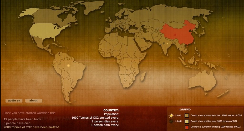
"Breathing Earth presents the carbon dioxide emission levels of every country in the World, as well as their birth and death rates - all in real time." Basically, it highlights countries in red when they emit 1000 tons of CO2. That's every 5.4 seconds for us over consuming Amercians and every 60.8 hours for the lovely Samoans. It also has a nifty counter that shows you how many folks have been born and died while watching the map. Check it out at http://www.breathingearth.net/.

Monday, September 11, 2006

Perry-Castaneda Library Map Collection

Happy Monday! I had a most relaxing and enjoyable weekend. I even had an oppurtunity to do my best karoake song, Elvira, on Saturday. I am a dork! Anyway, I figured I would dedicate today's post to the University of Texas Longhorns that didn't fair too well Saturday. Also, a new GIS Nation video is available.

"The Perry-CastaƱeda Library Map Collection at the University of Texas is a general collection of more than 250,000 maps covering all areas of the world. The Map Collection has major holdings of political, topographic and thematic maps of the world, continents, regions, countries, states and provinces. Major map categories include: USGS maps; Pre-1945 Topographic Maps;
Topographical maps from late 19th century to 1945; Topographic Quadrangles of the United States, 1882 - 1940 (GA 405 M64 1985 MAP); International Maps; Aeronautical Charts; Nautical Charts; Census Maps; City Maps; Flood maps; Park and Recreation Maps; Maps of national parks, monuments, forests and Texas State Parks; Sanborn Fire Insurance Maps. Many of the maps are included in the online catalog, UTNetCAT. More than 5,000 map images from the collection are also available online.

Friday, September 08, 2006

Google Maps Vs. Yahoo! Maps

As you can see, the blog is a changin! It is going to take me some time to get all of my fun little toys back on the right side, but it is much easier with Blogger beta. I just finished my first interview for the GIS Specialist position I have open. I have another this afternoon and then it's time for the weekend. Tonight, I am going for a nice bike ride and then imbibe with a few cold beverages. Tomorrow we have a friend coming to town for a visit. This is actually the friend that introduced the girlfriend and I. It should be a good one!

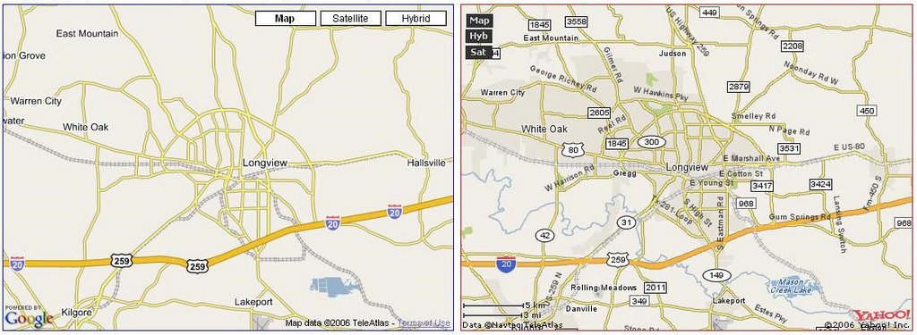
Have you ever wondered who would win if you put Google Maps and Yahoo! Maps next to each other? Well, Sergey Chernyshev makes that possible with his Google Maps Vs. Yahoo! Maps site. From the picture I posted Yahoo! looks much better, but the data is not very up to date. Enjoy looking at your hometown. Check it out at http://www.sergeychernyshev.com/maps.html.

Thursday, September 07, 2006

Mapping Globalization Project

I missed another post yesterday. I hope this doesn't become a habit with the increased workload that exists right now. Today, I'm preparing for interviews for the GIS Specialist position I have open. My interview process consists of a written and hands on test, as well as the traditional question/answer session. I also need to a get a handle on my budget with the end of the budget year fast approaching.

"With all the talk of globalization it is easy to forget that at the very core of the concept is a notion of geographical location. Globalization involves connections between at least two places and the first step in our understanding must be an appreciation of what this means in a concrete sense of space. Globalization involves movement—of people, goods, cultures, etc. One of the challenges of analyzing and displaying this phenomenon is that static images and text fail to convey the historical complexities and geographical patterns. The notion of a network may be the best means through which to appreciate the particular qualities of globalization, Most literally, networks are arrangements of connections into nets, or openwork systems linking groups of points and intersecting lines." Check out the Mapping Globalization Project at http://www.princeton.edu/~mapglobe/HTML/home.html.

Tuesday, September 05, 2006

MapPros!

I hope everyone had a good Holiday weekend. Caddo Lake is great! We saw some awesome birds, rode the swamp boat, ate some good food and I dominated at Monopoly. All in all it was an excellent long weekend. I will try to post some pics soon.

MapPros "is for students and others interested in learning about careers in geospatial technologies. It features career information and profiles of people who use geospatial technologies. People with skills in geospatial technologies are needed in a wide variety of fields, so the site was developed to encourage and assist those interested in exploring career options." Check it out at http://www.geospatialcareers.net/index.html.

Friday, September 01, 2006

Columbia Regional Geospatial Service Center

It's Friday!! I'm outta here at noon today to start my long weekend, but I have to work for it first. From 8-12, I have four meetings. Whew! I've got a staff meeting, an addressing ordinance discussion with the City Manager, an Emergency GIS Team meeting and a GIS Day planning committee meeting. If I survive all of that I'm off to play golf with my brother this afternoon and then we are headed to Caddo Lake for the weekend. Caddo Lake is one of the beautiful sites in Texas that I haven't seen yet. "Caddo Lake has been called the most beautiful lake in America by most who have seen it. It is also a lake of mystery and lots of history. Caddo Lake is the largest natural lake of fresh water in the south, covering about26,800 acres. " It should be a fun time if we don't run across any alligators.

"The Columbia Regional Geospatial Service Center (CRGSC), established in 2005 by Congress, is the national model for a growing network of regional centers, delivering the most up-to-date geospatial information and tools for regional support with emergency planning and response, economic development and natural resource management. CRGSC provides backup services, data storage and redundancy to other regional centers, and serves as a conduit between local, state and federal entities." Check it out at http://www.crgsc.org/.

Thursday, August 31, 2006

Windows Live Hotspot Locator

I didn't get a chance to post yesterday. It was a busy one. We were trying to get things wrapped up since my GIS Specialist is leaving the City. You can't blame the guy for the pay increase that he will be receiving. So, if you know any good GIS Specialists that are skilled in ArcSDE and ArcIMS that don't like money, send them my way.

"With 106,978 free and paid WiFi hotspots in 99 countries, Microsoft's Hotspot Locator makes it easy to locate wireless Internet access around the globe. Use the View on Map feature to see your search results on a map powered by Virtual Earth." Other services similar to this one have existed for some time, but I like the speed and ease of use of this one. Being able to see the aerial imagery of Virtual Earth is also a nice feature. Check it out at http://hotspot.live.com/web/SearchView.aspx

Planet Geospatial

ESRI.com - News

GISUser.com - The complete GIS, LBS, and Geospatial Technology Resource

A VerySpatial Podcast