Blogmap (by Feedmap) lets you geocode your blog, browse already geocoded blogs and search for blogs. Or as they put it "a place where blogs meet maps and location!". Once geocoded, you can get your own BlogMap location using a simple url that allows you to network with your local bloggers and much more! I also love the fact that the Blogmap is interactive. You can pan and zoom right on the blog. Too Cool! Get your own Blogmap at www.feedmap.net.
Wednesday, November 30, 2005
ClustrMaps & BlogMap (Feedmap)
Blogmap (by Feedmap) lets you geocode your blog, browse already geocoded blogs and search for blogs. Or as they put it "a place where blogs meet maps and location!". Once geocoded, you can get your own BlogMap location using a simple url that allows you to network with your local bloggers and much more! I also love the fact that the Blogmap is interactive. You can pan and zoom right on the blog. Too Cool! Get your own Blogmap at www.feedmap.net.
Tuesday, November 29, 2005
Planet Geospatial

It's Tuesday!!! Have you ever noticed that there is nothing exciting about Tuesday? Monday is the beginning of the week and Wednesday is the middle. Thursday is close to Friday and a good night to go out for drinks. Friday is of course the beginning of the weekend. Poor Tuesday :(
Planet Geospatial is an aggregation of public weblogs written by GIS Professionals and Hobbyists. This allows you to go to one place to catch up on all the great GIS weblogs. James Fee maintains Planet Geospatial and also has his own blog Spatially Adjusted (www.spatiallyadjusted.com) Check out Planet Geospatial at www.planet.spatiallyadjusted.com.
Monday, November 28, 2005
ePodunk
 Good Morning!! I hope everyone had a great Thanksgiving!! Mine was quite relaxing and I slept more than I have in months. I could use more four day weekends. Oh well, back to the grind :)
ePodunk provides in-depth information about more than 25,000 communities around the country, from Manhattan to Los Angeles, Pottstown to Podunk. When they say in-depth they mean it. You can find information from thousands of sources, including government agencies, databases, print reference works and news organizations. Their listings include geocoded information about thousands of parks, museums, historic sites, colleges, schools and other places across America. Their motto is "We believe in the power of place" and they make you believe in it too. Check out your community at www.epodunk.com!
Wednesday, November 23, 2005
Frappr
 Happy Thanksgiving Eve! I'll be out of the office till Monday so no posts till then. I'm leaving for the great City of Austin after work to enjoy my Holiday with the family. I'll try not to O.D. on the tryptophan!
Frappr is a cool site that lets you share and create maps on the internet using Google Maps. Or in their words, "Create maps for your group, share your favorite locations, or just explore!". You can also post and share pictures with an option to "map it!" I will be posting various pictures from different travels and events. I also created a map where I am inviting folks to post their location and picture. Please do so at http://www.frappr.com/gisgeoblog. You can also find the link and a picture slideshow at the bottom of the blog. You can find out more at www.frappr.com. Happy Thanksgiving!!!
Tuesday, November 22, 2005
Very Spatial
 Good Day! I've been trying to take advantage of my short week by catching up on projects that I have been putting off. I put in almost 13 hours yesterday, but we now have a GIS intranet site here at the City. Also, check out the GeoURL button on the bottom right of the page. GeoURL is a location-to-URL reverse directory. This allows you to find URLs by their proximity to a given location. Find your neighbor's blog, perhaps, or the web page of the restaurants near you. By clicking on the link you can see the sites near my home. Check it out at http://geourl.org/near?p=http://www.gis-geoblog.blogspot.com.
I am "Very" excited about today's post. VerySpatial.com offers a Very Spatial Podcast which is your weekly source for information on Geography and geospatial technologies. Geography touches most things we do everyday, but we rarely even think of it. This podcast seeks to point out how it is filtering into our digital lives and daily lives. The majority of the connections are currently through iTunes. You can also use one of the myraid of great RSS aggregators to connect using our Feedburner link. There is always the low tech version where you make sure you go to the page to download the podcast each week. The VerySpatial blog is intended to be a location for the hosts and participants of A VerySpatial Podcast to link to interesting sites and articles on Geography and related information. In addition to the blog itself the site hosts columns, links, and a few downloads on relevant topics. Check it out at www.veryspatial.com.
Monday, November 21, 2005
United States Department of Agriculture
Good Monday morning! We have a short week this week, yay! I wanted to share something that I enjoy on Mondays. National Public Radio (NPR) has a segment that they do called 'This I Beleive'. 'This I Believe' is based on a 1950s radio program of the same name. This exciting national project invites you to write about the core beliefs that guide your daily life. Find out more and listen at http://www.npr.org/templates/story/story.php?storyId=4538138.
The United States Department of Agriculture Geospatial Data Gateway provides One Stop Shopping for natural resources or environmental data at anytime, from anywhere, to anyone. The Gateway allows you to choose your area of interest, browse and select data from the catalog, customize the format, and have it downloaded or shipped on CD. Check it out at http://datagateway.nrcs.usda.gov/GatewayHome.html.
Friday, November 18, 2005
GIS Day Success Stories
 What a week!! Our GIS Day was great! We had over 125 people attend that viewed maps, applications, videos, etc. I can't say that I'm not glad it is over, but it was alot of fun and we are already planning next year's event! To see more success stories or to submit your own go to http://www.gisday.com/success.html. Have a great weekend! I will be eating my first turkey dinner of the season with my girlfriends family. Mmmmmmmmm!
Wednesday, November 16, 2005
Happy GIS Day!!
 Happy GIS Day!!!! Thousands of events around the world will most definitely be furthering the goal of increasing awareness and sharing knowledge about geography and geographic information system (GIS) technology in every corner of the globe. Here at the City we are ready to share the knowledge. The maps are hung, the demos are wired and the staff is excited. Let the fun begin! I wish everyone a successful and rewarding GIS Day!!!
Tuesday, November 15, 2005
Geographic Resources Analysis Support System (GRASS)
 Good Morning! As you can see it is early, but we must get started early to setup for GIS Day. Cross your fingers for us that all goes well.
Geographic Resources Analysis Support System, commonly referred to as GRASS, it is a Geographic Information System (GIS) used for geospatial data management and analysis, image processing, graphics/maps production, spatial modeling, and visualization. GRASS is currently used in academic and commercial settings around the world, as well as by many governmental agencies including NASA, NOAA, USDA, DLR, CSIRO, the National Park Service, the U.S. Census Bureau, USGS, and many environmental consulting companies. To find out more go to http://grass.itc.it/index.php.
Monday, November 14, 2005
The Geographic Information Center
 2 Days to GIS DAY!!! I hope that everyone that is holding an event is almost ready. Preparations can be a little overwhelming, but it is worth it to spread the word about our important technology. Oh yeah, the Shrimpfest was good this weekend, but we also participated in an art walk which was even better. Very relaxing!!
The Geographic Information Center of the National Academies works to build understanding of the relevance and importance of geographic information for addressing societal needs and to point the user to the rich array of ongoing National Academies activities and published reports (readable and searchable for free on the Web) on this topic. Check it out at http://gi.nationalacademies.org/.
Friday, November 11, 2005
The GIS Portal
 It's Friday!!! I'm ready to sleep, eat shrimp and work ALL weekend! I don't mind because it means that I am not traveling somewhere. That may sound odd, but I just want to stay home for a while.
 The GIS Portal is your source for mapping technology since 1994! The GISPortal (also known as Great GIS Net Sites!) is one of the top web sites for Geographic Information System (GIS) industry information. If you like maps, mapping technology, cool on line 3D mapping software, and the best look at the GIS market anywhere, this is the place! Check it out at www.gisportal.com. Have a great weekend!!
Thursday, November 10, 2005
Directions Magazine
 Good day! The weekend is almost here and I am ready for some much needed sleep! I also plan to participate in the Shrimpfest in Nacogdoches. That's right!! Even though we are 150 miles inland we are having a Shrimpfest. Why not???
 Directions Magazine publishes weekly newsletters about geographic information systems, global positioning systems, desktop mapping, cartography, computer-aided design, remote sensing, web services, and more. They also offer sections on jobs, tools and data, web map gallery and a map gallery. Check it out at www.directionsmag.com.
Wednesday, November 09, 2005
David Rumsey Historical Map Collection
 It's hump day and one week to GIS Day!!!! We are in full preparation mode here. I just hope we don't forget anything major.
 The David Rumsey Historical Map Collection has over 12,600 maps online. The collection focuses on rare 18th and 19th century North and South America maps and other cartographic materials. Historic maps of the World, Europe, Asia and Africa are also represented. Collection categories include antique atlas, globe, school geography, maritime chart, state, county, city, pocket, wall, childrens and manuscript maps. The collection can be used to study history, genealogy and family history. You can even purchase reproductions. Check it out at www.davidrumsey.com.
Tuesday, November 08, 2005
U.S. Fish and Wildlife Service
 Hola! The week continues with preparations for GIS Day (8 Days!) and the pilot project phase of data cleanup here at the City. If anyone has some interesting GIS news please send it my way for posting. I'll leave you with a joke:
Q: Why did the dot go to college?
A: Because it wanted to become a graduated symbol.
The U.S. Fish and Wildlife Service GIS Home Page provides information on metadata efforts in FWS, free spatial data, and serves as a clearinghouse for other GIS topics such as data standards, training, the A-16 process, global positioning systems, contract information, and technical notes. Data available includes U.S. Fish & Wildlife Office Locations, Interactive Map and Data Server Data Links, National Wetlands Inventory (NWI) Data, Migratory Bird Conservation Data Center: bird population and habitat information, FWS Ecosystem Coverages, Migratory Bird Flyways, etc. etc. To find out more visit http://www.fws.gov/data/.
Monday, November 07, 2005
Geospatial Solutions
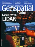 I hope everyone had as an enjoyable weekend as I did. I saw some old friends, helped celebrate a beautiful marriage, and enjoyed some wonderful sushi. It doesn't get any better than that. 9 days to GIS Day!!!
 Geospatial Solutions is the objective and authoritative forum for emerging intelligence about GIS and related spatial technologies. Industry leaders and peers define issues and share solutions critical to forging a community among professionals from diverse application environments. It is also FREE! You can learn more and subscribe at http://www.geospatial-online.com/geospatialsolutions/.
Friday, November 04, 2005
Google Print
Here's to a long life and merry one.
A quick death and a easy one.
A pretty lover and a true one.
A cold beer and another one!
A quick death and a easy one.
A pretty lover and a true one.
A cold beer and another one!
I am featuring the brand new Google Print today. Google Print was released yesterday. As described on their site: "The world's libraries are a tremendous source of knowledge, much of which has never been available online. One of our goals for Google Print is to change that, and today we've taken an exciting step toward meeting it: making available a number of public domain books that were never subject to copyright or whose copyright has expired. We can show every page because these books are in the public domain. (For books not in the public domain we only show small snippets of the work unless the publisher or copyright holder has given us permission to show more.)" I know this is not totally GIS related, but if you do a search for GIS you will see approxiamtely 260 different books. Just think about what kind of resource this is in your everday work. You can see more at www.print.google.com. Have a great weekend!
Thursday, November 03, 2005
GIS Nuts
 Good Morning! Thanks to GISuser.com for mentioning this blog on their daily email newsletter. What a surprise! Thanks again Glenn!
Today I'm featuring a fun website, gisnuts.com. These folks have come up with some great t-shirts for the GIS addicts like myself. I think my favorite is "I survived a NAD shift". I'll be placing my order soon!! Check them out at www.gisnuts.com.
Wednesday, November 02, 2005
GISuser

I'm back!! Did you miss me? I've finally uncovered myself from the mountain of work so that I can post again. GIS Day preparations are starting to come together so life is good.
I'm going to talk about GISuser.com today. GISuser.com is the most comprehensive, current, and information-rich resource for the GIS, mapping, GPS, geopositioning, and geospatial technology user. They have GIS news, tutorials, software reviews, GIS job listings, RFPs, webmaps, free tools, community discussion, newsletters, data, etc. etc. I also enjopy their daily newsletter which is always quite informative. Take a look at www.gisuser.com. Enjoy!!
Subscribe to:
Posts (Atom)


