| The story of how GIS was used in the recovery of the space shuttle Columbia. | |
Wednesday, December 06, 2006
GIS in the Face of Tragedy
Monday, October 16, 2006
toEat

It's been a while! We have been busy as ever at work. Our focus has been on process flows and quality control for our data that we got back from our consultant. The time constraint has made me half way consider discontinuing the blog, at least for a while. I'll see how the next week goes and then decide. Have a good one!
"toEat.com aims to be the central point for hungry people and restaurants to congregate. Our first release, the restaurant browser system, is only a small piece of what is on the toEat.com roadmap. In the next 6 months we're going to be building up features to allow restaurant owners to manage their own Internet websites, online advertising portfolios, and interactive solutions for bringing more customers into their restaurants by effectively showing people what is available to them." Check it out at www.toeat.com.
Monday, October 09, 2006
Global Hotel Index
 Good morning! It's been a while since I posted last. Part of the reason is that I was at the Oklahoma SCAUG conference in Oklahoma City. I gave a presentation on the GIS Certification Institute and GIS certification. Also, as a SCAUG officer, wanted to show our support to the Oklahoma chapter. They are by far a model of what we want to create in all of our chapters. I didn't do much over the weekend, but work most of the day on Sunday. Today, we continue on our mission of mapping process flows for all 64 of our layers.
"Global Hotelindex Ltd, founded in Switzerland, is a privately held company focused on hotel search services and tourism related advertising." So what do they have to do with geospatial technology? Not much, but they have a really cool flash based map that is used to zoom into your area of interest. Check it out at http://www.globalhotelindex.com/.
Tuesday, October 03, 2006
Population Action International
 G'Day! Well, the GIS Specialist came back today. I didn't scare him off with the thought of doing process flows and quality control on 64 layers. Today, we have another GIS Day planning committee meeting. We will be discussing the "What is GIS" section of our event. This afternoon the GIS Specialist and myself will hopefully wrap up our discussion on current projects. Oh yeah, I forgot to mention that our GIS Technician got a new title with the new budget year. He is now the GIS Data Steward. I don't think he is too keen on the name, but it is fitting. Has anyone else heard or used this title?
 "How many people will live on the planet 20 years from now? Where will they live? Where will population grow, and where will it decline? The map on Population Action International page illustrates a projected possible answer to these questions, applying new methods of mapping population density and of projecting its future." Check it out at http://www.populationaction.org/resources/publications/mappingthefuture/index.htm.
Monday, October 02, 2006
National Geographic MapMachine
 Happy Monday! I've been slacking on making my posts again. Since I last posted I attended diversity training at the City. It was an excellent class and taught in a unique way. It was more fact based than "you should do this" or "you shouldn't do that". Hopefully it will help to improve some attitudes. Friday we got all of our data back from our consultant and it was loaded into the geodatabase. Now the big work starts of quality control. Today, our new GIS Specialist starts. We will be spending the majority of the day reviewing policies and work projects that need to be worked on immediately. I'm going to leave you today with a couple of quotes that I got from the diversity training that I think could help us all get along a little better. "Life, at its' best, is a creative synthesis of opposites in fruitful harmony" - Dr. Martin Luther King Jr. "You must be the change you wish to see in the World" - Gandhi.
The National Geographic MapMachine powered by ESRI allows you to locate nearly any place on Earth, find country facts, and search and print historical, weather, and population maps, and more with this dynamic atlas. Check it out at http://plasma.nationalgeographic.com/mapmachine/index.html.
Wednesday, September 27, 2006
Free GIS Data & Imagery GeoBlog
 Evening! The second and final day of Intro to ArcGIS went smoothly. I even got an awesome crystal globe from one of my students. Too cool! I'm also working late again! It's hard to keep up with the day to day and teach. What am I complaining about? I love it!!
The GISUser, aka Glenn Letham, has a new blog out called the Free GIS Data & Imagery GeoBlog. This is Glenn's attempt at stopping folks from paying for public domain GIS data. It contains public domain GIS data and Free GIS data repositories and clearinghouses. As Glenn says, "Are you still paying commercial data resources for Free, public domain GIS data? If so STOP IT and WAKE UP! Are you looking for Free GIS data products like DRG, DEM, DLG, DOQQ, Census data, or ? Search no more!" Check it out at http://gisdata.blogspot.com/.
Tuesday, September 26, 2006
World66
 Nî hâo! I'm teaching Intro to ArcGIS today. So far we haven't had any major glitches (with people or computers). I'm getting excited because we are getting our data back from our consultant this Thursday. They will be loading it into SDE and then we will be ready for quality control. Too cool!
"Let's start with their credo: We believe that travelers are the best source of travel information. World66 is an open content travel guide, where people from all over the planet can write about the places they love, the hotels they stayed in, the restaurants that have eaten. Every part of the travel guide can be edited directly, just click the [edit] button and go ahead. You can change the info you find, do a write up, add a complete city or just a bar or a restaurant. Thanks to this approach World66.com has become one of the most complete travel resources on the internet, with 94,510 articles on 34,732 destinations all over the world. Good info, more up to date than you find in travel books. Check for yourself. And should you find some wrong info, a hotel that has closed down, whatever, don't complain, but act. You can change it. It's up to you." You can also create maps to use on your blog or MySpace that show where you have traveled or where you want to travel. Check it out at http://www.world66.com/.
Monday, September 25, 2006
The Daily Render
 Guten Tag! As you might have noticed I missed another post on Friday! I have been such a slacker lately. This weekend I used our wares to help in the search for Brandi Wells, a missing woman here in town. It is interesting to see the inner workings of a major search effort like this. If you ever have the opportunity to help with something like this, please do so. You will be surprised to learn that the search organizations don't even know you exist, but will be very happy to have your help. I have many meetings today and I'm teaching Intro to ArcGIS tomorrow. Wish me luck!
Nikolas Schiller uses imagery to create what he calls geospatial art. The photo I have posted here is from Dallas, TX. From what I gather Nickolas is a Geography student at George Washington University, but his true love seems to be his art. He also is a strong proponent of the Green Party and the fact that our country is run by big business corporations. Check it out at http://nikolasschiller.com/blog/.
Thursday, September 21, 2006
Yes.com
 Talofa! Does anyone know what that means? Anyway, another day down and it's almost Friday. I've actually been getting caught up on alot this week since I haven't had many meetings and the requests have been slow. I do have a few meetings tomorrow, but nothing major so the flow of productivity should continue. Be sure and take a look at the pics from the Austin City Limits Music Festival that I posted at the bottom of the page. The captions are courtesy of the girlfriend.
Yes.com, a website that covers the most listened to stations in the top 150 locations in the US, has created a "an online geographical visualization of the songs that are currently played on those stations in real time." It's pretty cool because you see the titles of the songs pop up all around the country on a Flash map. Check it out at http://www.yes.com/yesnation.swf.
Wednesday, September 20, 2006
Geospatial Industry Workforce Information System
 Good evening! I got quite a bit accomplished today since I didn't have any meetings. Tomorrow will be the same. So, if you have been waiting on an email or phone call from me, tomorrow may be your lucky day. We are getting close to officially announcing the East Texas Geospatial Conference that is in the works for November. We are also making some progress with GIS Day. Oh yeah, we are also getting all of our data back next week from our consultant........too busy!!
"GIWIS, or the Geospatial Industry Workforce Information System, is the nation's first and only online geospatial workforce information network. Whether you’re a veteran to the geospatial industry or you've just heard about this exciting technology, GIWIS is Colorado's one-stop resource for finding jobs, qualified employees, educational resources, schools, industry data, salary information, and much, much more! This exciting and constantly evolving pilot project is funded by the Department of Labor, through a $700,000 grant to "Define and Communicate Geospatial Industry Workforce Need." The site has been designed by the Geospatial Information & Technology Association and the Association of American Geographers to be a model site for other cities." Check it out at http://www.giwis.org/.
Tuesday, September 19, 2006
MAPS.com
 Good evening! It has been a while since I posted last, but I've been having all sorts of adventures. We had an East Texas GIS & GPS User Group meeting last Thursday which consumed most of my day. We had an excellent turnout with close to 50 which may be our highest attendance ever. On Friday I took a little vacation to Austin to attend the Austin City Limits Music Festival. It was awesome!! We saw Gnarls Barkley, Jimmy Dale Gilmore, deadboy and the Elephantmen and Van Morrison........and that was just on Friday. Not to mention the girlfriend spotted and talked to Matthew McConaughey. Too cool! The night would have ended a little better if I hadn't decided to have a little bike crash on the way home. Dudes back got a little baged up, but I'm Ok. On Saturday we heard Los Lobos, String Cheese Incident, Guy Clark and Willie Nelson. Afterwards, we went to the Broken Spoke (a south Austin landmark) and heard the great Dale Watson play. Sunday included Damian "Jr. Gong" Marley, Matisyahu, Ben Harper, The Flaming Lips and Tom Petty. Wow! It would have been an incredible weekend if I didn't have the biggest migraine I've ever had yesterday afternoon. The girlfriend had to leave school early to get to seclusion at home. I'm still feeling the effects today and hopefully will be 100% tomorrow........because I really need to answer all of these emails.
Do any of you cartographers think you have what it takes to sell your products? "Maps.com, Founded in 1991 as Magellan Geographix, is a leading provider of mapping products and solutions to business, education and consumer markets. MapMarketplace generates new income for cartographers by selling their content through Maps.com's online map store, visited 500,000 times each month. Maps.com's MapMarketPlace uses a process called Publish on Demand (POD) to connect cartographers with customers, requiring no pre-printed inventory from you- only digital files of your content. With POD, your product requires no costly print runs allowing you to become a map publisher with absolutely zero cost and zero risk. Maps.com handles all order and product fulfillment, from credit card processing to printing and laminating, and shipping to the customer. Here's how MapMarketPlace works:1) Register and submit your products online with MapMarketplace.2) Maps.com reviews your products and contacts you regarding acceptance.3) Accepted products are turned into live, sellable items within the Maps.com website. All product information is optimized for search engine visibility and marketed through newsletters, Maps.com affiliate sites and on-site promotions.4) When a sale occurs, we print, laminate and fulfill orders for your products and provide all customer service. When digital files are purchased, they too are transmitted to the consumer directly from Maps.com.5) You can view your earnings on MapMarketplace's real-time online sales reports.6) Payments are made 45 days after the close of a month and are issued directly from Maps.com. Maps.com handles everything from product page development to search engine optimization to order fulfillment and customer service. Every month your products sell, you will receive a check for 30% of the gross sales amount." Not a bad deal!!! Check it out at http://www.maps.com/mdcmp-learn.aspx?nav=MP.
Wednesday, September 13, 2006
MODIS Active Fire Mapping Program
 Good evening again! The days are growing.....it's 6:30 and I'm still at work. That's OK because I actually feel like I'm catching up. We officially hired our new GIS Specialist today. I also got prepared for the East Texas GIS & GPS User Group meeting tomorrow. It should be a good one. We are officially announcing the East Texas Geospatial Conference. More on that in the near future. I'm off to have Vietnamese with my lovely girlfriend. Hasta manana!
 The MODIS Active Fire Mapping Program is a great program put out by the Remote Sensing Applications Center of the USDA Forest Service. The first map you come to is current large fire events. You can click on the event and see the actual Incident Management System Report. You also have access to regional maps, ArcIMS maps, imagery, GIS data, fire detections and some other neat products. Check it out at http://activefiremaps.fs.fed.us/.
Tuesday, September 12, 2006
Breathing Earth
 Good evening! Late post tonight, but I'm getting one in. It was busy, but worth it. I got an evaluation completed that is only four months overdue and am close to hiring a new GIS Specialist. Not a bad days work!!
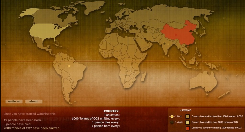
"Breathing Earth presents the carbon dioxide emission levels of every country in the World, as well as their birth and death rates - all in real time." Basically, it highlights countries in red when they emit 1000 tons of CO2. That's every 5.4 seconds for us over consuming Amercians and every 60.8 hours for the lovely Samoans. It also has a nifty counter that shows you how many folks have been born and died while watching the map. Check it out at http://www.breathingearth.net/.
Monday, September 11, 2006
Perry-Castaneda Library Map Collection
 Happy Monday! I had a most relaxing and enjoyable weekend. I even had an oppurtunity to do my best karoake song, Elvira, on Saturday. I am a dork! Anyway, I figured I would dedicate today's post to the University of Texas Longhorns that didn't fair too well Saturday. Also, a new GIS Nation video is available.
 "The Perry-Castañeda Library Map Collection at the University of Texas is a general collection of more than 250,000 maps covering all areas of the world. The Map Collection has major holdings of political, topographic and thematic maps of the world, continents, regions, countries, states and provinces. Major map categories include: USGS maps; Pre-1945 Topographic Maps;
Topographical maps from late 19th century to 1945; Topographic Quadrangles of the United States, 1882 - 1940 (GA 405 M64 1985 MAP); International Maps; Aeronautical Charts; Nautical Charts; Census Maps; City Maps; Flood maps; Park and Recreation Maps; Maps of national parks, monuments, forests and Texas State Parks; Sanborn Fire Insurance Maps. Many of the maps are included in the online catalog, UTNetCAT. More than 5,000 map images from the collection are also available online.
Friday, September 08, 2006
Google Maps Vs. Yahoo! Maps
 As you can see, the blog is a changin! It is going to take me some time to get all of my fun little toys back on the right side, but it is much easier with Blogger beta. I just finished my first interview for the GIS Specialist position I have open. I have another this afternoon and then it's time for the weekend. Tonight, I am going for a nice bike ride and then imbibe with a few cold beverages. Tomorrow we have a friend coming to town for a visit. This is actually the friend that introduced the girlfriend and I. It should be a good one!
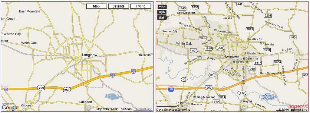
Have you ever wondered who would win if you put Google Maps and Yahoo! Maps next to each other? Well, Sergey Chernyshev makes that possible with his Google Maps Vs. Yahoo! Maps site. From the picture I posted Yahoo! looks much better, but the data is not very up to date. Enjoy looking at your hometown. Check it out at http://www.sergeychernyshev.com/maps.html.
Thursday, September 07, 2006
Mapping Globalization Project
 I missed another post yesterday. I hope this doesn't become a habit with the increased workload that exists right now. Today, I'm preparing for interviews for the GIS Specialist position I have open. My interview process consists of a written and hands on test, as well as the traditional question/answer session. I also need to a get a handle on my budget with the end of the budget year fast approaching.
"With all the talk of globalization it is easy to forget that at the very core of the concept is a notion of geographical location. Globalization involves connections between at least two places and the first step in our understanding must be an appreciation of what this means in a concrete sense of space. Globalization involves movement—of people, goods, cultures, etc. One of the challenges of analyzing and displaying this phenomenon is that static images and text fail to convey the historical complexities and geographical patterns. The notion of a network may be the best means through which to appreciate the particular qualities of globalization, Most literally, networks are arrangements of connections into nets, or openwork systems linking groups of points and intersecting lines." Check out the Mapping Globalization Project at http://www.princeton.edu/~mapglobe/HTML/home.html.
Tuesday, September 05, 2006
MapPros!
 I hope everyone had a good Holiday weekend. Caddo Lake is great! We saw some awesome birds, rode the swamp boat, ate some good food and I dominated at Monopoly. All in all it was an excellent long weekend. I will try to post some pics soon.
MapPros "is for students and others interested in learning about careers in geospatial technologies. It features career information and profiles of people who use geospatial technologies. People with skills in geospatial technologies are needed in a wide variety of fields, so the site was developed to encourage and assist those interested in exploring career options." Check it out at http://www.geospatialcareers.net/index.html.
Friday, September 01, 2006
Columbia Regional Geospatial Service Center
 It's Friday!! I'm outta here at noon today to start my long weekend, but I have to work for it first. From 8-12, I have four meetings. Whew! I've got a staff meeting, an addressing ordinance discussion with the City Manager, an Emergency GIS Team meeting and a GIS Day planning committee meeting. If I survive all of that I'm off to play golf with my brother this afternoon and then we are headed to Caddo Lake for the weekend. Caddo Lake is one of the beautiful sites in Texas that I haven't seen yet. "Caddo Lake has been called the most beautiful lake in America by most who have seen it. It is also a lake of mystery and lots of history. Caddo Lake is the largest natural lake of fresh water in the south, covering about26,800 acres. " It should be a fun time if we don't run across any alligators.
"The Columbia Regional Geospatial Service Center (CRGSC), established in 2005 by Congress, is the national model for a growing network of regional centers, delivering the most up-to-date geospatial information and tools for regional support with emergency planning and response, economic development and natural resource management. CRGSC provides backup services, data storage and redundancy to other regional centers, and serves as a conduit between local, state and federal entities." Check it out at http://www.crgsc.org/.
Thursday, August 31, 2006
Windows Live Hotspot Locator
 I didn't get a chance to post yesterday. It was a busy one. We were trying to get things wrapped up since my GIS Specialist is leaving the City. You can't blame the guy for the pay increase that he will be receiving. So, if you know any good GIS Specialists that are skilled in ArcSDE and ArcIMS that don't like money, send them my way.
 "With 106,978 free and paid WiFi hotspots in 99 countries, Microsoft's Hotspot Locator makes it easy to locate wireless Internet access around the globe. Use the View on Map feature to see your search results on a map powered by Virtual Earth." Other services similar to this one have existed for some time, but I like the speed and ease of use of this one. Being able to see the aerial imagery of Virtual Earth is also a nice feature. Check it out at http://hotspot.live.com/web/SearchView.aspx
Tuesday, August 29, 2006
Manifold System
 Good morning! Our consultant is coming by today to install our raster catalog for our geodatabase. This is the first set of data that we will be loading into SDE. Quite exciting!! I know, you are probably thinking we are behind. This is true. Although, we should have a full functioning enterprise GIS in less than a year. Then we can play catchup with custom applications and even more integration enterprise wide. Wish us luck!
The new buzz is about Manifold System. Here is what their news page says: "The next generation of Manifold System products has been issued as Release 7x. This new generation product provides a relatively limited number of new items in the release notes (about 100) but introduces a systematically re-engineered product that now optionally delivers full 64-bit, native mode functionality when run on x64 Windows systems running AMD or Intel x64 processors, including multi-core x64 processors. Manifold System is the first true 100% 64-bit Windows GIS!" I'm not the most knowledgable on computer architecture so I did a little research on 32-bit versus 64-bit processors. According to Wikipedia 64-bit architectures can indisputably make working with huge data sets easier. "The main disadvantage of 64-bit architectures is that relative to 32-bit architectures the same data occupies slightly more space in memory (due to swollen pointers and possibly other types and alignment padding). This increases the memory requirements of a given process and can have implications for efficient processor cache utilization." So, you can handle larger data sets, but you probably need more memory. Check it out at http://www.manifold.net/index.html.
Monday, August 28, 2006
Hurricane Katrina & Rita Clearinghouse Cooperative
 Happy Monday! We had a great SCAUG meeting on Friday. We are really making some progress in some areas that we wanted to focus on this year. The girlfriend also had an old friend in for the weekend. We entertained and had a night out on the town Saturday night. Not a bad weekend!
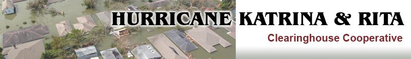
 Since the anniversary date just passed, I thought I would talk a little about Hurrican Katrina data. The Hurricane Katrina & Rita Clearinghouse Cooperative "has been established at the Louisiana State University, Baton Rouge to facilitate the collection, dissemination, and archiving of data related to Hurricane Katrina and Rita. It was established in the aftermath of Katrina as a central repository of geospatial data related to the disaster for affected areas of Louisiana. It was also expanded to maintain perishable data from Rita and Wilma. Initiated through FEMA and LSU collaboration, the Clearinghouse facilitates many of the data access and distribution needs of FEMA, state, and local efforts. In addition to the downloadable data available through the website, the Clearinghouse stores information that is not for public release and provides secure access for appropriate agencies. Managing the data and the data requests are faculty, research associates, and graduate students at LSU. These personnel comprise a vast range of research, technical, and managerial skills necessary for effective geospatial decision support." Check it out at http://katrina.lsu.edu/default.asp.
Thursday, August 24, 2006
The ArcPad Team Blog
 I'm rushing around to get things wrapped up before I hit the road to Dallas this evening. I have a South Central Arc User Group board meeting in the morning and I'm taking the oppurtunity to go up a night early to see some old friends. It should be a blast since I know it will consist of cold beverages and old stories. To kill the wasted time on the road, I'm currently downloading some ESRI podcasts and a few episodes of the Very Spatial podcast. I'm a nerd, but it is better than hearing songs I've already heard 100 times. I'll do my best to post tomorrow, but these meetings are usually hectic. If not, have a great weekend!
"The ArcPad team has created a blog as an informal focal point where they can share knowledge, tips & tricks, tools, news and just about anything else they think might be interesting related to ArcPad." You can find some great posts such as: Performance Tips # 1 : Shapefile drawing speed tuning with greeking; Raster Tips # 1 - Choosing a raster format; Debugging Tips # 1 - Using the ArcPad 7 Console Window; Where in the ArcPad World are you?; UC2006 Over : A Successful Conference for ArcPad Users and the Team; GeoCollector Field Data Collection Solution Now Available; ActiveSync 4.2; ArcPad Today Powertoy; ArcPad and the 2010 U.S. Census; ArcPad at the 2006 ESRI International User Conference. Check it out at http://arcpadteam.blogspot.com/.
Wednesday, August 23, 2006
Planetizen Radar
"Planetizen is a public-interest information exchange provided by Urban Insight for the urban planning, design, and development community. It is a one-stop source for urban planning news, commentary, interviews, event coverage, book reviews, announcements, jobs, consultant listings, training, and more. Planetizen is read by a diverse array of people interested in the built and natural environments, and their interaction. Planetizen's audience includes professional urban planners, developers, architects, policy makers, educators, economists, civic enthusiasts and others from across the United States and around the world. Planetizen prides itself on covering a wide number of planning, design, and development issues, from transportation to global warming, architecture to infrastructure, housing and community development to historic preservation. We provide a forum for people across the political and ideological spectrum, ensuring a healthy debate on these and other important issues." Check it out at http://www.planetizen.com/.
Tuesday, August 22, 2006
American Society for Photogrammetry & Remote Sensing
 Good morning! I had a nice game of tennis last night. My co-worker and I beat the ladies 6-1. Of course, we played a short set and the ladies won 3-1. We felt sorry for them! Ha! Speaking of my co-worker, he is moving on to another city for better opportunities. Do you know any good GIS Specialists out there that don't really like money, but want to learn a lot and help create a progressive enterprise GIS? If so, send them my way. Have a great day!
I can't beleive I've been blogging for almost a year and I haven't talked about the American Society for Photogrammetry & Remote Sensing (ASPRS). "The mission of the ASPRS is to advance knowledge and improve understanding of mapping sciences and to promote the responsible applications of photogrammetry, remote sensing, geographic information systems (GIS), and supporting technologies. Founded in 1934, the ASPRS is a scientific association serving over 7,000 professional members around the world. Our mission is to advance knowledge and improve understanding of mapping sciences to promote the responsible applications of photogrammetry, remote sensing, geographic information systems (GIS), and supporting technologies. The American Society for Photogrammetry and Remote Sensing (ASPRS) has officially incorporated the tag line "The Imaging and Geospatial Information Society," as part of the ASPRS identity. This tagline is representative of the Society's "New Vision," as it makes the changes necessary to better position its focus for the future." Check it out at http://www.asprs.org/.
Monday, August 21, 2006
GISnation
 Well, most of my day was spent on addressing. This seems to be a recurring theme lately. I will be glad when we get it all squared away so we can move on to other more important projects. I've got another meeting tomorrow to discuss our proposed addressing ordinance with our legal division. What fun!
GISnation is a new blog with a video cast. You can watch their inaugural video cast from San Diego. They definitely hit the high points of the ESRI UC. They speak about the plenary, their favorite vendor gimmicks, their favorite map in the map gallery and their favorite parties. Oh yeah, they went to a few technical sessions as well. You must check this out to see the crazy cello guy and how great Geographers dance. I loved it and I can't wait for the next episode. Check it out at http://gisnation.blogspot.com/index.html.
Friday, August 18, 2006
Global Forest Watch
 It's Friday!! What a week. It's always rough coming back from a conference. Although, I must say I have been very productive this week. We have a GIS Day planning meeting today. This year we are breaking the event into sections: What is GIS?; GIS in Infrastructure Management; GIS in Emergency Response; GIS in Development; GIS in Education. This morning we will be brainstorming for the GIS in Emergency Response section. I'm going to try and sneak out early to get a jump on our trip to Austin. I'm meeting up with a buddy that I haven't seen since high school tonight. We have much to catch up on! Saturday, the family is going to make a trip out to Wahlberg to enjoy the best German food and bier garden in Central Texas. Have a good one, I know I will!
The Global Forest Watch is an organization dedicated to collecting and distributing comprehensive forest information to insure they are sustainably managed. They provide several interactive maps and much data at no cost from their web site. In fact, Susan Minnemeyer, their GIS Lab Manager was named a GIS Hero by ESRI. You can find the story in the latest copy of ArcNews. Check out their site at http://www.globalforestwatch.org/english/index.htm.
Thursday, August 17, 2006
BlockRocker
 It's going to be another busy one! We have a GIS User Committee meeting this morning. I'm going to present some of the new enhancements that are coming in ArcGIS 9.2 and give an overview of the ESRI UC. After lunch I'm going over to our COG to discuss 911 addressing for our county. That should be interesting. On the home front we are preparing to go to Austin this weekend to see friends and family. We have big plans for German food on Saturday night. Yummm!
BlockRocker is online classifieds with a map. "Creating Ads on BlockRocker is Fast, Easy, and Free. Anyone can sell anything, anywhere, completely for free. Reach your street, neighborhood, city, state, and the whole world. No site registration required. Totally free. Simpler than eBay, and no listing fees. Communication options make it easy to sell: privacy-protected email, phone, Skype, AOL Instant Messenger, and more. Printable versions of your ad are perfect for coffee rooms, residence bulletin boards, or wherever. Create a classified or wanted ad, or post any message or announcement that you'd like people to see. And, its all easy and fast to do! Creating you ad takes only three simple steps: Show us where the item is by choosing your location; Fill in your contact and pricing information, and describe the item; Preview and confirm your ad, and its instantly online!" Check it out at http://www.blockrocker.com/.
Wednesday, August 16, 2006
Society of Women in GIS
 Hola! Believe it or not I don't have any meetings today. It's a good thing because I have alot to catch up on. I spent a few hours last night working on the mini-conference we will be having here in East Texas. It should be a great event and you will be hearing more as the preparations come together. On a personal note, the girlfriend has me eating healthy and working out. I had tofu for dinner the other night and I actually enjoyed it! Also, my arms and stomach are so sore from pushups and crunches which I don't really enjoy. Wish me luck! Also, for the other bloggers out there, has anyone had trouble uploading pictures to blogger? Frustrating!
"The Society of Women in GIS (SWIGIS) was founded in 1999 in response to the need for an organization for women employed or studying geographic information systems (GIS). Historically underrepresented in the field, women now are making strides in geography and GIS. SWIGIS members come from all fields and are employed in many areas: government, academia and the private sector. SWIGIS will serve as an organization of mutual support to all women employed in GIS. It will strive to improve the recruitment, retention, and education of women in the field of GIS. Objectives include: A. Promote opportunities for women so that the field of GIS may adequately reflect the diversity of the GIS workforce. B. Promote the retention of women in GIS by providing a support network where female members of the GIS community can find out about current happenings in the field, educational opportunities and discuss GIS technologies. C. Build coalitions with like-minded organizations in order to promote common objectives." Check it out at http://www.swigis.org/4436.html.
Tuesday, August 15, 2006
Alertdude Groups
 Well I have read through my 150 emails at least once from being out last week. It almost doesn't pay to leave town. Anyway, I've got several meetings today. First, we are setting up our WebEOC product all day. Unfortunately, I have to miss part for a meeting about City owned property and the Supervisor's Network. This month's topic is Media Relations. I'm also going to do my best to spend some time on the planning of our little mini-conference here in East Texas tonight. Have a good one!
Groups is a site that let's "people map easily, and organize their interests into groups. The purpose of a group is to organize common interests. Some examples include 'Jobs', 'Houses', etc. A group can be anything you like, and can map anything you like. You can list in any group as many times as you like. You create listings within groups. A listing can include a title, a description, and one picture. It can be about anything you want, but should be related to the group it's in." I added myself to the GISUser Group that is tracking GIS professionals. Check it out at http://www.alertdude.com/groups/index.php.
Monday, August 14, 2006
Fantom Planet
 I survived the ESRI UC! It was an incredible, but busy week. As you can tell I only got two posts out. Next year I will do better. Although, I met all my other goals of the conference. I learned more about ArcWeb Services and found an easy way to replicate/transfer data between us and the appraisal district using ArcGIS Server. If you haven't heard the mid range version of this will be delivered free of charge to those that already own ArcIMS and ArcSDE. Of course my other goal was to meet up with friends and make some new ones. I was fortunate enough to do both. What a week!! Look for pictures and more info in the coming days.
 Occasionally, I like to point out other blogs out there. "Fantom Planet is "some random geographer's" opinionated output about all things geospatial, geotechnical, and whatever else on location based information and services." Fantom Planet put together the Geoblogger meetup at the ESRI UC which I regrettfully missed. Maybe I'll catch it next year! Anyway, Fantom Planet talks shop with alot more humor than I can ever come up with. Check it out at http://fantom-planet.blogspot.com/.
Wednesday, August 09, 2006
26th Annual ESRI User Conference - Day 3
As you can tell, I missed day 2. Too much is going on here. We had our South Central Arc User Group social last night and the turnout was incredible. We had good food, good drinks and good fun. Today has been a series of technical sessions and the one I just left for ArcWeb Services was GREAT! I had no clue that you could also easily create a mashup using ESRI software. What will call these? I guess it will have to be the ESRI mashup!! Gott run to another session. I'll try again tomorrow.
Monday, August 07, 2006
26th Annual ESRI User Conference - Day 1
Day 1 has been full of surprises!!! The morning started with Jack's normal enthusiasm about GIS. He discussed themes such as the GeoWeb and being able to serve GIS data. He addressed Google Earth in a surprising light. He said it was good because it helped open the World's eyes to geographic information. Although he was clear to point out that it is not GIS and that Explorer will have that ability. Their was much more that I will cover in the coming weeks. The afternoon provided an insight into the work that 4-H is doing with GIS. Former senator Bob Kerrey gave an excellent speech about how we need to continue doing the work we are doing and that we must think on a global level. Again, their was much more, but I must run to the map gallery social. Pictures will have to wait until I return. I'll try to post more tomorrow.
Friday, August 04, 2006
WinTopo
 Happy Friday! As the week winds down I still find myself trying to get those loose ends tied up that I have been mentioning all week. Hopefully, I can get that accomplished before five today. If not, I'll be working late on a Friday. Yuck!! In addition we are installing the GIS portion of our WebEOC application today. The great part is that I have not seen the documentation and I'm not even sure what it does. That's what happens when another government agency buys things for you. Anyway, for those that are going to the ESRI User Conference, maybe I'll see you out there. For those that aren't going, I'll be thinking about you while I'm basking in the 70 degree weather. I'll do my best to post some pics and give a recap everyday. Have a great week!
 "WinTopo is a high quality software application for converting TIF, JPG, PNG, GIF, BMP files and scanned images into useful vector files suitable for CAD, GIS and CNC applications. WinTopo comes in two flavours: Freeware and Pro. The freeware version is completely free for everyone to use. This is a highly capable piece of software which produces better results than most expensive commercial alternatives. Over a million users worldwide have already taken advantage of this powerful converter. For most people there is no need to look any further (or to spend any money). Download it right now and start converting your images with the One-Touch Vectorisation button." They also have a video online that shows you just how easy this is. I'm downloading my copy right now. Too cool! Check it out at http://www.wintopo.com/.
Thursday, August 03, 2006
GeoDa
 Good morning! I hope day two of Intro to ArcGIS is more exciting than day one. I only have five folks in the class and they are not giving much feedback. I'll see if I can spice it up a bit today. I'm also trying hard to get some loose ends tied up before the big ESRI UC next week. If you are attending and want to meet some of the authors of your most popular GIS blogs and possibly yours truly, try to make it to the Geoblogger meetup. Fantom Planet put this together at the Mister Tiki Mai Tai Lounge at 801 5th Ave at 8 PM. On the home front, we had an awesome game of tennis last night. It went 7-7 and then the tie breaker ended in 6-4. What fun!
"GeoDa is the latest incarnation in a long line of software tools developed by Dr. Luc Anselin's Spatial Analysis Laboratory (SAL) in the Department of Geography at the University of Illinois, Urbana-Champaign. It is designed to implement techniques for exploratory spatial data analysis (ESDA) on lattice data (points and polygons). The free program provides a user friendly and graphical interface to methods of descriptive spatial data analysis, such as spatial autocorrelation statistics, as well as basic spatial regression functionality. The latest version contains several new features such as a cartogram, a refined map movie, parallel coordinate plot, 3D visualization, conditional plots (and maps) and spatial regression." Check it out at https://geoda.uiuc.edu/default.php.
Wednesday, August 02, 2006
Christine
 I've been teaching Intro to ArcGIS all day and I just got a chance to make a post. It's going to be an action packed end of the week as I prepare for the ESRI International User Conference. I want to get as much out the way prior because I know it will be a beast when I return. Although, I'm getting very excited about the conference. Do you know of any 'can't miss' events this year? By the way, I will be doing my best this year to blog from the conference by posting pictures and a recap of the day. Stay tuned!
"Christine is a useful, easy-to-use tool that brings geographic information to your desktop. Christine gives you the power to visualize, explore, query and analyze data spatially. A key feature of Christine is that it's easy to load tabular data, such as dBASE® files and data from database servers. Using Christine you can display, query, summarize, and organize this data geographically." Did I mention it is free!!!! Check it out at http://www.christine-gis.com/.
Tuesday, August 01, 2006
GeoRSS
 I'm up early today! I've got some reports due by noon and a meeting this morning so I've got to get started. We are meeting with our local University to discuss addressing their buildings. It seems they have never had addresses for each individual building, but one address for the entire campus. That's a little dangerous in an emergency situation. I also have a meeting this afternoon to discuss collaboration between multiple counties in the area. This is our first meeting on the subject so I'm interested to see how it turns out. Also, for those attending the ESRI User Conference in the South Central region be sure to stop by the SCAUG social on Tuesday afternoon. It should be a good time!! On a final note, the geoblog just had it's best month ever with a 1,000 unique visitors. It sure is nice to know someone out there is reading!
"GeoRSS describes a number of ways to encode location in RSS feeds. As RSS becomes more and more prevalent as a way to publish and share information, it becomes increasingly important that location is described in an interoperable manner so that applications can request, aggregate, share and map geographically tagged feeds. To avoid the fragmentation of language that has occured in RSS and other Web information encoding efforts, this site has been created to promote a relatively small number of encodings that meet the needs of a wide range of communities. By building these encodings on a common information model, we hope to promote interoperability and "upwards-compatibility" across encodings.
At this point we have completed work on two encodings which we are calling GeoRSS GML and GeoRSS Simple. GeoRSS GML is a formal GML Application Profile, and supports a greater range of features than Simple, notably coordinate reference systems other than WGS84 latitude/longitude. It is designed for use with Atom 1.0, RSS 2.0 and RSS 1.0, although it can be used just as easily in non-RSS XML encodings. GeoRSS Simple has greater brevity, but also has limited extensibility. It can be used in all the same ways and places as GeoRSS GML." Check it out at http://www.georss.org/.
Monday, July 31, 2006
HostGIS Linux
 Good morning! I need a weekend from my weekend. We were in Dallas this weekend visiting the girlfriends sister. We stayed up a bit too late both Friday and Saturday night. We also had basically every Asian food possible. Dim-Sum (Chinese if you didn't know), Phillipino, Korean and Japanese. Yummm! This afternoon at work we will proceed with our GIS Day plans and have a meeting to discuss were we are. Have a good day!
"HostGIS Linux is a Linux/GNU distribution specifically made for handling GIS information. HostGIS Linux saves hours or days of installing MapServer and its components, and will have you serving GIS maps in minutes. It includes: All the usual amenities of a Linux distribution (compilers, Perl, etc.); Apache webserver, with PHP; MapServer, and MapScript for PHP, Perl, and Python; PDFlib, with support built in to PHP, Perl, Python, and MapServer; PostGIS-enabled Postgres database server; MapServer Web Client (MWC) to display great interactive maps without designing any HTML or JavaScript; Example maps already installed: shapefiles, ECW raster, PostGIS, MyGIS, WMS server and client, and Flash output; Webmin, phpMyAdmin, and phpPgAdmin for easy system administration." I'm not a Linux user, but it sounds like a good deal to me. Check it out at http://www.hostgis.com/linux/.
Friday, July 28, 2006
STARS
 Happy Friday! I had an excellent meeting yesterday to plan a two day conference here in East Texas. It should be an great event, so stayed tuned for more details. Today, I've got to get over to our library to make sure the computers are ready for my Intro to ArcGIS class next week. This weekend the girlfriend and I are off to the Dallas area to visit family. We will most definitely take in some sushi and some cold beverages. Have a great weekend!
"Space-Time Analysis of Regional Systems (STARS) is an open source package designed for the analysis of areal data measured over time. STARS brings together a number of recently developed methods of space-time analysis into a user-friendly graphical environment offering an array of dynamically linked graphical views. It is intended to be used as an exploratory data analysis tool. STARS can also be used from the command line to support more flexible and specialized types of analyses by advanced users. As such STARS should appeal to a wide array of users. Written entirely in Python, STARS is crossplatform and easy to install (and expand). " Check it out at http://regal.sdsu.edu/index.php/Main/STARS.
Thursday, July 27, 2006
GMapEZ
 Good day! I've got to go to Stephen F. Austin State University this morning for a meeting to discuss having a one day GIS conference for the East Texas GIS & GPS User Group. We are looking at some time in early November. It should be a good event. Also, if you haven't planned your agenda for the ESRI UC your time is running out. You can plan everything out and save it on the ESRI site. Don't forget to attend your user group meeting on Tuesday evening. I know SCAUG has some big things planned.
 GMapEZ helps you put a Google map on your web page? "With GMapEZ there's no JavaScript to write and nothing to download". It's pretty cool because it walks you through each piece of the Google API. Everything from the intial map to adding markers to info windows. Check it out at http://bluweb.com/us/chouser/gmapez/.
Wednesday, July 26, 2006
DIVA-GIS
 Good morning! I'm at the office early getting ready for a couple of meetings this morning. We have a budget review meeting where our City Manager practices his presentation to our City Council. We usually find out about raises at this one. Keep your fingers crossed for us poor City employees. Afterwards, I have a meeting with our economic development corporation to discuss a joint ArcIMS site. My hopes are not too high on this one. They seem to be leaning towards doing their own thing, which may be a bad idea, since no one there has any GIS experience. On the home front, I will be dominating folks on the tennis court again tonight. Bring it suckerz!
"DIVA-GIS is a free mapping program that can be used for many different purposes. It is particularly useful for mapping and analyzing biodiversity data, such as the distribution of species, or other 'point-distributions'. With DIVA-GIS you can: Make maps of the world or of a very small place, integrating, for example, state boundaries, rivers, a satellite image, and the locations of sites where an animal species was observed; Make grid maps of the distribution of biological diversity, to identify “hotspots” and areas that have complementary levels of diversity; Map and query climate data; Predict species distributions using the BIOCLIM or DOMAIN models; Create ESRI shapefiles; import and export grid data; and much more!
You can also download AVID-GIS (version 0.3), the command line version of DIVA-GIS or have a look at a simple implementation of Google Maps; expect more on-line DIVA soon..." Check it out at http://www.diva-gis.org/.
Tuesday, July 25, 2006
((Echo)) MyPlace
 Good evening! I've been trying to get a post out all day! Meetings, meetings and more meetings is the story right now. We have been trying to get the 911 addressing squared away since we took it over a few weeks ago. What fun! Have a good night!
"((Echo))MyPlace™ lets you share and find location-based information about your neighborhood and connect directly with friends and neighbors. You can create your own digital real estate and travel guides, ads, lost and found notes, event flyers, surveying tools and more. You can also add your pictures and link them to your places – and then instantly share them with CarbonCloud. Also, form your own CarbonCloud neighborhood to spread your message. Once your neighborhood is online it connects people who want to get connected, and grows as notes and pictures are shared from one person to another - the more people share, the more your message spreads. Build your network - CarbonCloud neighborhoods complement city WiFi projects – you can even create your own CarbonCloud neighborhoods and establish a local digital community in a meeting room, office site, household or the next door neighbors.
Grow your business - Businesses can communicate directly with customers and provide them with the information they need about the latest events, products and services." Check it out at http://www.echomyplace.com/.
Monday, July 24, 2006
Conservation Geoportal
 Happy Monday! I had a great weekend. After my marathon trip to San Antonio for the SCAUG board meeting (which was very productive), we went to Shreveport on Saturday afternoon. We spent the day losing money in the casino, shopping and enjoying drinks with friends. I hope yours was as enjoyable.
"The Conservation Geoportal is a collaborative effort by and for the conservation community to facilitate the discovery and publishing of geographic information systems (GIS) data and maps, to support conservation decisionmaking and education. It is primarily a data catalog, intended to provide a comprehensive listing of GIS data sets and map services relevant to biodiversity conservation. The Conservation Geoportal does not actually store maps and data, but rather the descriptions and links to those resources, known as "metadata." It includes the following capabilities: Search for data and maps by keyword, category, geography, or time period; Save your search queries for future use; Use the built-in Map Viewer to display, manipulate, and combine live map services; Create, save, and email custom maps using data from various map services; Publish metadata for your maps and data so others can find them. The Conservation Geoportal is designed to make it quick and easy for conservation practitioners to find, and if possible, preview and download GIS data and maps. Similarly, it is easy for conservation data publishers to post metadata describing the data and maps they want to share, how to access them, and under what terms. This is a free tool for all conservation practitioners and supporters to use and contribute content. We hope that it will minimize the proliferation of geospatial data catalogs and reduce duplication of effort in building and maintaining metadata catalogs and map viewers." Check it out at http://www.conservationmaps.org/Portal/ptk.
Thursday, July 20, 2006
National Geographic World Music
 Good day! I'm working feverishly to get some things out of the way before I leave for Austin this afternoon. I'm going to see the family tonight and then it's off to San Antonio in the morning for a South Central Arc User Group board meeting. We have a full agenda so it will be a long day, especially since I'm driving back to Longview tomorrow night. I'm not sure if I will have internet access so you may not see a post tomorrow. Have a good day and a good weekend!
"World music is Israeli reggae and Japanese klezmer. It's rock and roll from the Sahara and flamenco with a hip-hop breakbeat; it's digital bossa nova and Irish sean nos with an African pulse. It's downhome country music from someone else's country and smooth, urban R&B from the mega-cities of the Southern Hemisphere. It's cowboy music from Venezuela and Persian classical music from L.A. It's music that transcends borders. In our interconnected world a great song can come out of anywhere: crossing oceans and continents, and leveling barriers of race, religion, nationality, class and even language. Worldwide hits can emerge as easily from Lagos or New Delhi as London or New York. This is the essence of what's become known as world music: it's the soundtrack of globalization, and the sound of the world we live in today. Music transcends categories, too, and there's no fixed definition for world music. It's a slippery term - as changeable and varied as the music it attempts to describe. To some, world music is field recordings and ethnographic music, for others it's simply pop music from somewhere else. Many consider world music a marketing concept and a catchall for the various international sounds that aren't easily categorized; while many more consider it an alternative to the mainstream. All of these definitions are correct: World music contains multitudes. World music is the sound of human genius and creativity, constantly renewing and reinventing itself as old sounds mutate into new and young talent preserves and reinvigorates tradition. World music is the sound of humanity singing to itself. It's the natural sound our planet makes when you tune in to the right frequency. And it's quite possibly the sound of your next favorite song." Check it out at http://worldmusic.nationalgeographic.com/worldmusic/view/
page.basic/home.
Wednesday, July 19, 2006
SERVIR
 Hola! Hump day begins ...... no meetings this morning, but I have three this afternoon. They range from discussing sex offenders, installing software and looking at work order management software. Hopefully, I can get caught up on some work this morning. Have a great day!
"SERVIR is a regional visualization and monitoring system for Mesoamerica that integrates satellite and other geospatial data for improved scientific knowledge and decision making by managers, researchers, students, and the general public. SERVIR addresses the nine societal benefit areas of the Global Earth Observation System of Systems (GEOSS): disasters, ecosystems, biodiversity, weather, water, climate, oceans, health, agriculture, and energy. For example, SERVIR can be used to monitor and forecast ecological changes and severe events such as forest fires, red tides, and tropical storms. SERVIR headquarters are located at the Water Center for the Humid Tropics of Latin America and the Caribbean (CATHALAC) in the Republic of Panama. A test bed and rapid prototyping SERVIR facility is managed by the NASA Marshall Space Flight Center at the National Space Science and Technology Center in Huntsville, Alabama." Check it out at http://servir.nsstc.nasa.gov/index.html.
Tuesday, July 18, 2006
GeoServer
 Howdy! As you can see I didn't post at a reasonable time again. We had a user committee meeting this morning that went well. We had a great presentation exposing our users to different types of analysis. Then it was off to the supervisors network where we discussed performance reviews. Yawn! In the afternoon I met with several water utility managers to discuss ways that GIS can help them in their jobs. All in all it was productive and tiring. I'll sleep well tonight.
"GeoServer is an Open Source server that connects your information to the Geospatial Web. With GeoServer you can publish and edit data using open standards. Your information is made available in a large variety of formats as maps/images or actual geospatial data. GeoServer's transactional capabilities offer robust support for shared editing. GeoServer's focus is ease of use and support for standards, in order to serve as 'glue' for the geospatial web, connecting from legacy databases to many diverse clients. GeoServer supports WFS-T and WMS open protocols from the OGC to produce JPEG, PNG, SVG, KML/KMZ, GML, PDF, Shapefiles and more. Geoserver is built on Geotools, the same Java toolkit that udig uses. GeoServer is a truly open community, with a well documented and modular codebase, so don't hesitate to get involved." Check it out at http://docs.codehaus.org/display/GEOS/Home.
Monday, July 17, 2006
Active Volcanoes
 Good evening! I just don't have enough time lately. I only had three meetings, but I felt like I wasn't in my office at all and I didn't even take a lunch. My meeting this morning was with our appraisal district and it looks like we will be sharing a single geodatabase for all of our data and creating a ArcIMS site for both entities. That's exciting news!! This afternoon we met with our Planning department and we are officially taking over 911 addressing as of this afternoon. More exciting news (and a little scary)! On the personal side of life we had an excellent weekend. We visited the balloon race on Friday night and it was an amazing experience. Look for a couple pics on Frappr soon. We also had time to catch a movie, go for a swim, and had a very hot bike ride. Peace!
Active Volcanoes (spelled wrong on the site) is a Google mashup that shows "volcano activity Reports available from the Smithsonian Institute (USGS Weekly Volcanic Activity Report)and the VOLCANO mailing list. Database and additional information from:Smithsonian Institution, Global Volcanism Program." Check it out at http://www.geocodezip.com/v2_activeVolcanos.asp.
Friday, July 14, 2006
SAGA GIS
 No meetings today, but I couldn't even find time to update the blog!! We have many projects going on and it's been a long day. Anyway, enough crying. The girlfriend and I are off to the Great Texas Balloon Race here in Longview. That is the largest hot air balloon event in Texas and it should be a good time. When it gets dark tonight they do what they call the balloon glow which is supposed to be beautiful. Have a great weekend!!!
"SAGA – System for Automated Geoscientific Analyses- is a hybrid GIS software. The first objective of SAGA is to give (geo-)scientists an effective but easy learnable platform for the implementation of geoscientific methods, which is achieved by SAGA's unique Application Programming Interface (API). The second is to make these methods accessible in a user friendly way. This is mainly done by the Graphical User Interface (GUI). Together this results in SAGA's true strength: a fast growing set of geoscientifc methods, bundled in exchangeable Module Libraries.The figure shows SAGA's system architecture. SAGA is written in the widespread and powerful C++ programming language and follows an object oriented approach. Moreover it relies on the GNU Public License, which means it is an open source project. All this designates SAGA to be a first choice tool for everybody who works in the field of geosciences, in particular for those who want transparent state of the art methods." Check it out at http://www.saga-gis.uni-goettingen.de/html/index.php.
Thursday, July 13, 2006
The Tour de France in 3D
 Good morning! Not much news again today. We continue to press forward on our field verification of addresses and addressing standards. I'm also working on scheduling another Introduction to ArcGIS I course. Other than that it is business as usual. Have a great day!
I'm excited about todays post because if you have taken a look at my profile I enjoy riding the bike on occasion. Although, the Tour is not too exciting now that Lance is not destroying the other rider. "Tour de France and Google team up to offer you the full 3D route of the Tour de France in Google Earth. You will no longer miss anything: reliefs, stage cities, results, departures or arrival lines… Rediscover the Tour with Google Earth. Never miss a stageSave the Tour de France Route in your “favorites” and enjoy an automatic update of course information." Check it out at http://www.letour.com/2006/TDF/LIVE/us/400/
r2_google_earth.html.
Wednesday, July 12, 2006
geotagthings
 Howdy! Another day in paradise begins. I've got a lunch meeting that is sponsored by our economic development corporation that focuses on economic development in the community. It's called the community roundtable and we go around the room and discuss items that we are working on that effect economic development. Anyway, I can't beleive I only have one meeting. Sweeet!!!
"Geotagthings is a simple way to assign any web resource — anything with a URL - a location in the normal, human physical world. Why would anyone want to assign a geographic location to a web page? The simple reason is that people are already doing various projects that fell within the scope of making web data also geographic data and we felt that there was a need for a low-impact, easy to use tool to help in our own little way. The more involved reason is that the Internet and other networks are very rapidly spilling out into the physical world. Whether you call it pervasive networks, ubiquitous computing or the geospatial web, one can easily anticipate that the networks need geographic semantics. In the physical world, location means more than a uniform resource locators (URLs). In the physical world, the data that is sluicing around also needs to know where it is according to an additional set of geographic information, such as latitude/longitude, or relative location to canonical landmarks, or simply the town or city in which that previously non- geotagged data has relevance. We feel that Geotagthings is an important component of the larger toolkit of collaborative mapping projects. It provides a bottom-up resource for networked public contributions to mapping the web and making web resources "findable" and relevant to activities in the physical world. We also felt the need for an additional, lightweight, open tagging mechanic for adding geographic semantics to things to go along with all of the other wonderful geo and location-based networking services already out there. Geotagthings is just one more arrow in the quiver." Unfortunately, you can only use geotagthings if you use Mac (OS X) - Camino, all versions or Firefox, all versions; On the PC - Firefox, all versions (not extensively tested, though). This knocks me out of the game so I couldn't really get a feel for it. Check it out at http://geotagthings.com/beta/.
Tuesday, July 11, 2006
BoatingSF
 Good day! Not much new for today. No meetings, which is a minor miracle. We are still fighting the Chechem at home. We also got our fill on some decent sushi last night. The girlfriend hasn't had any sushi in three months and needed some bad. It's nice not having many meetings and no plans for the week. I should try this more often.
 BoatingSF has a cool mashup that shows the recent positions of boats in the San Francisco Bay area. "The ship tracks shown on our San Francisco Bay ship tracking page come from a system called AIS (Automatic Identification System). Starting in 2002, all new commercial ships over 300 gross tons, and all new passenger vessels, are required to include AIS transponders. The AIS system transmits information encoded on two VHF channels, at 161.975 MHz 162.025 MHz. Transmissions use 9600 bit per second GMSK FM modulation and HDLC packet protocols. Each ship transmits during one of 2,250 time slots, so all ships can share the two channels. The two channels provide redundancy and some level of protection from interference. Transmission range is basically line-of-sight, like VHF voice traffic. Typical range is 20 nautical miles. The AIS transponder receives information from the ship's other navigational instruments. Position, course, and speed over ground information is typically provided by a GPS receiver. The ship's officers must enter information such as ship name, ship type, ship dimensions, and estimated time of arrival. This information is not always entered correctly and is sometimes out of date, which accounts for the peculiar information occasionally seen in the ship information panel on our ship tracking page. Ships that are moored or at anchor are required to transmit their position information at least every 3 minutes. Ships moving at up to 14 kts must transmit their position every seconds; at up to 23 kts, every 6 seconds; and at faster speeds, every 2 seconds. In addition, static information (such as the ship's name, destination, and estimated time of arrival) is transmitted separately every 6 minutes.
BoatingSF.com's San Francisco Bay ship tracking page displays information received from a SR161 receiver, supplied by Milltech Marine. The receiver is located in the Berkeley Hills. It connects to a serial device server, which converts the RS-232 signal to Ethernet and acts as a TCP/IP server. Our Web server maintains a TCP/IP socket connection to the serial device server and processes the data stream. Custom PHP software on our Web server decodes the messages and stores the AIS reports in a MySQL database. Every five minutes, software running on the Web server analyzes the last hour of AIS reports and creates an XML file that summarizes these reports. When you load our San Francisco Bay ship tracking page, a Flash program reads this XML file from the server and displays the animated ship positions. To reduce the amount of data that must be sent, the server provides position reports on a one-minute interval, and the Flash program interpolates from these positions." Too cool!!!!!! They make it sound so simple. Check it out at http://www.boatingsf.com/ais_map.php.
Monday, July 10, 2006
Globe4D
 Happy Monday! I had an excellent weekend with the girlfriend back home. Unfortunately, she is back to teaching summer school labs today. Not much rest! Also, if you ever go trouncing through the jungle in the Yucatan beware of the Chechem tree (aka Mayan Jungle Rot). It's like Poison Ivy on steroids and it hurts. We have tried numerous cures for the girlfriend throughout the weekend from Calamine lotion, antibitoic cream, swimming pool chlorine and salt paste. We are thinking the salt paste and chlorine is helping. Wish us luck with that!! On a work related note, I have a meeting this morning with the Citizens on Patrol (aka COPs). We want them to help with our field verification of addresses. The idea is to field verify every address in the City. Have any of you taken on such an endeavor? If so, what are the do's and don'ts? Have a good one!!
"Globe4D is a four dimensional direct manipulation device for globe viewing. ConceptGlobe4D is an interactive installation that consists of a physical sphere whereupon three dimensional images are projected. The projection can be controlled by the user. Unlike conventional globes, Globe4D shows dynamic images which can be viewed from all angles. This is a new way of displaying and interacting with geographical data over time. The user can interact with the globe in two ways. First: rotation of the sphere itself. Second: turning a ring around the sphere. By rotating the sphere the projected image rotates along with the input movement. Turning the ring controls time as the 4th dimension of the globe. In our installation the user experiences a time-shift of more than 750.000.000 years. You can perfectly see the continental drift during this time-travel! Of course Globe4D limitation boundaries are not fixed to the earth alone. Live weather images and daylight changes can be projected on the globe as well as climate changes, earthquakes and hurricanes. You can even think of going to the middle of the earth by zooming in on its crust peeling of the earth as if it is an onion. Of course Globe4D is not limited to the earth alone. The moon, the sun, mars and any other spherical object can be projected as well. The Globe4D concept consists of three parts: the Hardware, the Software and the Data Model. Check it out more at http://www.globe4d.com/index.php/.
Friday, July 07, 2006
MapGameDay
 Happy Friday! Today is the big day when my girlfriend returns from three months in Mexico. I'm leaving early from work at three to go to Dallas and bring her home. We have a big weekend planned of doing absolutely nothing. It will be good for both of us. On a GIS related note I caught this story from MySpace (beleive it or not). It looks like ESRI has some legal issues going on and has been subpoenaed in a probe of a lobbying firm. Read more at http://www.dailybulletin.com/news/ci_3992253. Have a great weekend!!!
 "MapGameDay is the place for football fans to create online sharable maps of their favorite college football stadium. Create Maps to your secret tailgate locations, your seats, or the aftergame party." As the creators put it, "MapGameDay has been the combination of several things that we really like- namely not getting lost at College Football Games. A game from last year is a perfect example. The game was in the afternoon, and I was meeting friends from out of town. The equation: Campus they were not familiar with +Poor cell phone reception +Tons of people wearing the same color shirt=2 extra miles of walking on a muggy September day
Determined not to let this happen to anyone again, we started our mission of not letting football fans down, especially when you travel to opponents stadiums. After quickly determining that our spare change would not be enough to build out decent cell towers across the country, and that nasty little incident with Kip's "time travel" machine, we decided why not a map. We hope you enjoy our little creation, and will tell lots of people." Check it out at http://www.mapgameday.com/index.php. Today is the Day!
Thursday, July 06, 2006
Stick It To Em'
 Hola! It's already been a busy one. I've already been out to an elevated water storage tank to help point an antenna at another tank using GPS. Now, I only have three more meetings today. Whew!! Holiday weeks are horrible because everyone tries to cram a week of work into three days. Tomorrow is the big day when my girlfriend returns! Have a great one!
Here is a cool article from Popular Science. "The StarChase system, which the Los Angeles Police Department will test this fall, consists of a laser-guided launcher and a miniaturized GPS tag complete with a radio transmitter and a blob of gummy adhesive. Once stuck to its target, the tag begins transmitting coordinates to a server through an encrypted cellular network. Computers superimpose the GPS data over a map that allows dispatchers to track the vehicle’s every move." What a great idea! No more car chases. Let the guy think he has gotten away and bust him while he is in line at the Taco Bell. Beautiful! Check it out at http://www.popsci.com/popsci/whatsnew/
73415ef7dfa1c010vgnvcm1000004eecbccdrcrd.html. 0 Days!!
Subscribe to:
Posts (Atom)


