 Happy Friday! We have big plans for the weekend, the annual Christmas parade is Saturday in Nacogdoches. Ha! Not much else going on. I look forward to a weekend at home. Have a great one!!
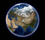
Google Earth has competition?? I didn't know it either until a coworker pointed me towards NASA's World Wind. Actually, I'm not sure you can call it competition since World Wind is open source and completely free. To see how the two differ check out this comparision. World Wind lets you zoom from satellite altitude into any place on Earth. Leveraging Landsat satellite imagery and Shuttle Radar Topography Mission data, World Wind lets you experience Earth terrain in visually rich 3D, just as if you were really there. Virtually visit any place in the world. Look across the Andes, into the Grand Canyon, over the Alps, or along the African Sahara. World Wind leverages Microsoft .NET technology for rapid development and to easily access open standards such as XML, WMS, and other graphics standards. Real-time 3D graphics are driven by DirectX allowing a wide base of compatibility with accelerated video hardware. Primary data sources come from NASA, and TerraServer-USA of Microsoft Research. Oh yeah, it also comes with World Wind Moon so you can explore the Moon too!!! Check it out at http://worldwind.arc.nasa.gov/index.html.


No comments:
Post a Comment