Friday, April 28, 2006

TrackStick

Wow what a week! Let's see, what didn't happen today? We had a kick-off meeting to start discussing GIS Day. I know it's early, but we are planning on a big event this year. The meeting was LONG! I also got a call at 3:30 that our computer lab in our Library died! This usually wouldn't be a big deal, but I had an Intro to ArcGIS class scheduled there Monday. So I got to contact everyone that was registered to tell them we would have to try another day. Oh yeah, I also got to read a letter from my stalker. Without going into much detail, a former disgruntled employee from a past employer decided to send a letter to my current employer to express his anger. It was three and a half years ago!! Let it go!

"The Track Stick records its own location, time, date, speed, heading and altitude at preset intervals. With over 1Mb of memory, it can store months of travel information. All recorded history can be outputted to the following formats: RTF (Detailed text file with .html map links); XLS (Microsoft Excel spread sheets); HTML (Webpage with graphics and maps); KML (Proprietary Google Earth file). The Track Stick receives signals from twenty four satellites orbiting the earth. With this information, the Track Stick can precisely calculate its own position anywhere on the planet to within fifteen meters. The Track Stick will work anywhere on the planet Earth. Using the latest in GPS mapping technologies, your exact location can be shown on graphical maps and 3D satellite images. The Track Stick's micro computer contains special mathematical algorithms, that can calculate how long you have been indoors. While visiting family, friends or even shopping, the Track Stick can accurately time and map each and every place you have been." This one makes me think big brother! Just think of the possibilities. Check it out at www.trackstick.com. 30 Days!

Thursday, April 27, 2006

Global-i

Ga Day! I just wanted to say that. It reminds me of one of the presenters on ESRI's live training seminar, Editing Tips and Tricks today. We held it in our Library so that all of our GIS Users could attend. It had some helpful pointers and hints, but man it was boring. I'm just glad I had the internet available to keep me awake. Don't get me wrong, I love that ESRI offers these free seminars, but they are not all as good as the others. Maybe it was the subject?

"Global-i is a 3-dimensional interactive globe that displays information about the world in your browser. The Earth can be rotated and inspected and displays can be changed to see information in the most appropriate form. Global-i has been described as "A Global Marketer's Dream" but it is not just for marketers or ecomomists. It is for anyone who wants to learn about the world and what makes it go round. By viewing this information in context, the world makes more sense. At present the emphasis is on economic data and there is plenty of other information too - health, infrastructure, energy, military...........and more - from present day back to 1960 and we are adding to this list all the time." This is Google Earth before Google Earth was born. Check it out at http://infoview.infomagnet.com/. 31 Days!

Wednesday, April 26, 2006

Earth Day Network

Hola! We had another Emergency GIS Team meeting today which went well. We talked about hardware needs and our site address field verification project. If anyone has done a field verification of addresses for an entire City I would love to hear about (good and spcifically bad). An emergency GIS team is not a new idea. Just do a Google search on emergency GIS and see what you come up with. New York City has a whole team devoted to this with a bus (or as they call it the Mobile Data Center). It is pretty cool. Check it out here.

First of all, I suck!! It was Earth Day and I didn't even recognize it on the blog. Although I did celebrate (fellas you know what I mean). "Founded by the organizers of the first Earth Day in 1970, Earth Day Network (EDN) promotes environmental citizenship and year round progressive action worldwide. Earth Day Network is a driving force steering environmental awareness around the world. Through Earth Day Network, activists connect, interact, and impact their communities, and create positive change in local, national, and global policies. EDN's international network reaches over 12,000 organizations in 174 countries, while the domestic program keeps over 3,000 groups and over 100,000 educators coordinating millions of community development and environmental protection activities throughout the year. As a result, Earth Day is the only event celebrated simultaneously around the globe by people of all backgrounds, faiths and nationalities. More than a half billion people participate in our campaigns every year." For those that didn't know Earth Day was April 22nd. Check it out at http://www.earthday.net/default.aspx. 32 Days!

Tuesday, April 25, 2006

Maps On Us

Good evening! It's budget time at the City and I am swamped. Let's count the ways: 911 addressing, emergency GIS team, GIS Day, employee reclasifications, inter-agency cooperation and data sharing, data conversion, etc. etc. etc. I'm not sure when I'm supposed to do the budget. That's probably why I have been working every night. I guess if my girlfriend had to leave the country this is the best time for it. 33 days!

Maps On Us is a mapping website run by Switchboard. "They are a leading provider of local online advertising solutions and Internet-based yellow pages, interconnecting consumers, merchants and national advertisers. Switchboard helps consumers quickly and easily find and compare local businesses offering specific products and services, while creating revenue opportunities for merchants." The maps are provided by Microsoft MapPoint. You can get driving directions, nearby businesses, etc. Check it out at www.mapsonus.com.

Monday, April 24, 2006

Geosense

Another Monday down. The weekend was pretty good. I went shopping, got a haircut, cleaned the apartment, went for a bike ride and hung out with the guys. We had too much fun Saturday night;) I got to pay for that on Sunday. Anyway, I got to talk to my girlfriend tonight. She is a little homesick, but doing well. For those that haven't been keeping up, she is in Mexico for three months working on her Masters thesis. I booked my flight tonight and it's still going to be 34 days before I get to see her again.

Geosense is a cool website that lets you test your knowledge of world geography alone or against another online player. You also get to pick between a World Map, Advanced World Map, Europe Map, US Map or a Scramble. The object is that a place name is given and you have to click on the closest location to it on the map. The closer you get the more points that are scored. I'm not sure if it is mostly kids on this site, but I have been killing on the US Map. Bring it!!! Check it out at www.geosense.net.

Friday, April 21, 2006

Gmaps 101 - An Introduction to Google Maps & The Google Maps API (Part 1)

Good Morning!! It's going to be a busy one. I've got a staff meeting, our monthly GIS User Committee, and a meeting about a partnership with another agency. The last one concerns us trying to use one central geodatabase for both us and another local entity. It sure would make our life easier if we could both share and edit the same data. Keep your fingers crossed for us.

I've got a special one today! GISUser.com had an article that I thought was too good not to share. It is titled Gmaps 101 - An Introduction to Google Maps & The Google Maps API (Part 1). It is written by Eric Pimpler the owner of Geospatial Training & Consulting, LLC, a provider of virtual and instructor led GIS training opportunities and the author of its popular virtual training course “Google Maps For Your Apps!” and the new PDF book “Google Maps API: The New World of Web Mapping”. Eric is also a Texan and has done some work for SCAUG! "In this first article of a three part series on the Google Maps API you will discover the fundamental programming constructs for developing web mapping applications with the hottest web mapping application development tool. Once we walk you through this tutorial you will feel comfortable with Google maps, you'll know how to get your own maps key, and be up and running with your own Google map with basic controls." Check it out at http://www.gisuser.com/content/view/8657/28/. Enjoy!!

Thursday, April 20, 2006

Traffic.com

Good evening! The budget season has started here at the City. I had training today and now the fun begins. For those that have never completed a budget it is not as easy as one might think. You have to insure all bases are covered. You want to isntitute new programs while not wanting to ask for too much. The fortunate part is that we are in pretty good economic times here so you don't have to worry too much about having part of your existing programs being cut.

"Traffic.com is one of the largest independent providers of traffic information and services in the U.S. They deliver traffic content to clients and consumers on terrestrial and satellite radio, on broadcast and cable TV, through wireless applications and services, and via the Internet. The Traffic.com site and the companion my traffic.com site at my.traffic.com are the primary "direct to the consumer" online services. They get their information from three types of sources: digital traffic sensors, commercial and government partners, and our traffic operations center staff members. The Traffic.com Jam Factor is like a "Richter Scale" for traffic. It's an overall measure of the traffic intensity on a roadway, or on a section of a roadway. Because the Jam Factor calculation uses real-time speed and travel time measurements from our digital sensors and those of our partners, as well as our detailed accident, construction and congestion information, it's a comprehensive measuring tool that is unique to Traffic.com." The map that they provide is great because it instantly shows where problem areas are and the intensity. Unfortunately, it is not available for all cities. Some day maybe... Check it out at www.traffic.com.

Wednesday, April 19, 2006

Favorite Run

Howdy! Well we narrowed down the search for the dispatching/routing software for our transit system. It's between Init and RouteMatch. If anyone has experience with either (good or bad). Please post a comment. Tomorrow, the budget process begins! Not exactly my favorite time of year. Oh well, we will get through it! Have a good night!

Favorite Run is a cool mashup that let's you map your running routes. "You can also View Pictures of Routes , Search over 21,000 Running Routes in Your Area, Calculate Running Distances Before You Leave Your House, Share your Favorite Runs With Others, Keep a Running Log and Track Your Statistics, Export Routes into Google Earth or GPX format, Sync Your Garmin Forerunner 201, Find a Running Partner (over 8000 registered runners), Promote a Race, Event, or Group Run, Publish a Calendar of Your Events, Provide Running Maps for Your Race or Blog, Shop Online for Running Products and Read Running Tips and Articles." Check it out at www.favoriterun.com.

Tuesday, April 18, 2006

Home Town Locator

It's been another long day. That's right, I'm just now finishing my day. I had three proposals for our transit system routing and dispatching software that I had to review before tomorrow. I must say I wasn't very impressed with any of them. They all want to use national data instead of local data. Hmm.. I guess all I can do is give my comments and pick the best one. I also just scared the hell out of myself!! I don't think I mentioned it before, but I love to bike (both road and mountain). One reason I haven't mentioned it is because I have not had a chance to do much of it in the last year because I lived so far from work. Anyway, I went for a ride yesterday and of course I got a flat. I'm not the most handy of guys so I thought for the first time I would try to patch this one. So I put the patch on, get the tire back together and start pumping it up. It pops!!! It sounded like gunfire in my little apartment. My heart just now slowed to a normal pace. Whew!!!

"Home Town Locator has community profiles for 42,500 US cities, towns and ZIP codes with census, demographic and income data, parks, schools, libraries, hospitals, airports, environmental conditions, local newspapers, media outlets, employment, maps, coordinates and aerial photos." It's a pretty cool resource if you are doing some data mining or just general research about a location. Check it out at www.hometownlocator.com.

Monday, April 17, 2006

WorldAtlas

I'm sorry!! I have been neglecting my loyal readers. It's been a long, hectic, depressing, draining last five days, but that's no excuse. Let's see....Wednesday I had a lunch meeting with many different organizations around the City that deal with economic development. That's not a bad group to know. Anyway, I couldn't get around to the blog and I left immediately after work for Dallas. On Thursday I had a SCAUG/NCTCOG Regional GIS meeting which went well. We had about 100 attendees. That night I got to catch up with some old work friends and enjoy some adult beverages. Friday we spent in Dallas with my girlfriends sister. Of course, we partied some more. Sadly, on Saturday I said goodbye to my girlfriend for the next three months. She will be in the Yucatan at beautiful Rancho Santa Maria working on her thesis research. I can't wait to visit at the end of May. So, to drown my sorrows I went to Austin for the rest of the weekend to party some more. Wow what a weekend!! Sorry to ramble, but I had alot to catch up on. I'll try to post everyday, but it may be at night. Work is a little crazy right now.

"In 1987, Graphic Maps in Dallas, Texas was established. At that time the company created colorful, illustrated maps of major worldwide cities, then marketing the maps to the retail, travel and visitor industries, as well as establishing individual map businesses throughout the country. Initially, all of the maps were laboriously drawn by hand, until the computer industry grabbed his attention. Today, all of his cartography is produced in Adobe Illustrator® and Adobe Photoshop®. Graphic Maps grew dramatically, and today, their award-winning maps are used in more applications then there is room here to mention. Worldatlas.com - one of the spin-offs from Graphic Maps - was developed in the spring of 1996, in an effort to aid students, teachers, travelers and parents with their geography, map and travel questions. Today it's one of the most popular educational sites on the web, receiving hundreds of questions and tens of thousands of visitors each day." Check it out at www.worldatlas.com.

Tuesday, April 11, 2006

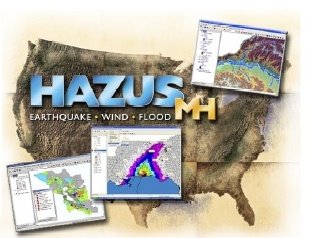
HAZUS

Good evening! It's been a busy one. We had our first regional emergency GIS team meeting at the City. We formed it to help in times of crisis. With the hurricane season coming soon we thought we might want to get a jump on it (we actually had to activate our EOC for both Katrina and Rita evacuees). This team is made up of several City departments and the County. We discussed issues like data availability, hardware, software, events, etc. Hopefully it will help if anything does happen. I included information today on HAZUS to go along with the theme.

"HAZUS-MH is a powerful risk assessment software program for analyzing potential losses from floods, hurricane winds and earthquakes. In HAZUS-MH, current scientific and engineering knowledge is coupled with the latest geographic information systems (GIS) technology to produce estimates of hazard related damage before, or after, a disaster occurs. HAZUS-MH takes into account various impacts of a hazard event such as: Physical damage: damage to residential and commercial buildings, schools, critical facilities, and infrastructure; Economic loss: lost jobs, business interruptions, repair and reconstruction costs; and Social impacts: impacts to people, including requirements for shelters and medical aid. Federal, State and local government agencies and the private sector can now order HAZUS-MH free-of-charge from the FEMA Distribution Center." Check it out at http://www.fema.gov/plan/prevent/hazus/index.shtm.

Monday, April 10, 2006

GPS World

The weekend was nice. I even got in a bike ride!! We also did way too much shopping and got the girlfriend partially packed for Mexico. She is leaving next Saturday for three months in the Yucatan to study woodpeckers. Life is tough! Just kidding, she will actually be working pretty hard collecting data.

"GPS World, the magazine, has covered the global positioning industry since 1989." They have the website, an Early Edition newsletter and The Digital Edition. "Electronically reproducing the full print issue, launched in mid-2005. Complete, convenient (browser-based, with no fat files or mandatory downloads), interactive (live, zoomable, thumbable, with immediate clickthrough to advertisers' and other referenced sites), and portable -- download it to your computer for offline reading and archiving. For continuous innovation in delivery of the freshest, most comprehensive GPS/GNSS-related news to high-level corporate managers, project and engineering managers, product designers, researchers, and system developers, all of whom rely on GPS World when making purchase decisions in a $5.8 billion market" — just keep watching www.gpsworld.com.

Thursday, April 06, 2006

Multimap

It's almost Friday! We have a meeting this afternoon with our consultant to discuss the status of our implementation project. We have alot to discuss so it should be an important one. Other than that, it is business as usual.

"Multimap is Europe's leading provider of mapping and location-based services. Our company delivers more online maps, point-to-point driving directions and geo-spatial ("where's my nearest?") searches to businesses and consumers than any other supplier in Europe. The website offers a range of free, useful services to assist with everyday life. Key features include street-level maps of the United Kingdom, Europe, and the US; road maps of the world; door-to-door travel directions; aerial photographs; and local information. Multimap also provides a range of complementary services through its partners. These include entertainment, hotel, holiday-cottage, restaurant and train-ticket booking services, SMS weather alerts and the ability to buy both historic and aerial photograph prints." Check it out at http://www.multimap.com/.

Wednesday, April 05, 2006

Censustrax

Unpacking is officially complete! I'm surprised we finished that quickly and that everything seems to fit in our apartment. Since that little chore is complete and I am closer to work, I can start putting some serious hours in to catch up on some projects here at the City. So many ideas, so little time!

"CensusTrax is an on-line interactive web GIS service to quickly retrieve, map and export US Census data. CensusTrax serves as the base framework for the géoflash Explorer system and thus can be fully customized to suit unique needs. The géoflash Explorer CensusTrax system is a hybrid (or Mashup) of Google Maps, the géoflash Explorer system (an Open Source Flash web GIS), YaHoo's National Geocoding service, and the entire block level US Census. The system seamlessly overlays translucent, interactive géoflash demographic maps on top of a Google map. The overlaying “intelligent” géoflash maps can perform thematic analysis, be clicked-on for information retrieval, display mouseover tooltips and query a dynamic geo-relational database. The Google base map, in turn, provides seamless national coverage and smooth dynamic panning and zooming. YaHoo's geocoding service provides accurate and lightening-fast address location for the entire United States." Check it out at http://www.censustrax.com/.

Tuesday, April 04, 2006

flagr

Good Morning! The unpacking is coming along nicely. I am really enjoying my new place. I'm not sure if it is because it is more modern than our old place or that it is smaller, but I feel more apt to keep it tidey. I hope to finish unpacking tonight and start hanging things on the walls.

Flagr is a cool site that lets you share your travels with your cell phone. "The founders believed there should be an easy way for EVERYONE to share where they go, while on the go. Such a system would not be limited to use with fancy GPS-enabled mobile phones. Instead, it would rely on the already-popular text messaging infrastructure available on almost every cell phone. With such a system, users previously excluded from such services can take part in an extraordinary social experience. They can Sharewhere, anywhere. Whether exploring new places or revisiting their favorite venues, most everyone you know is constantly exploring. Every now and again, you may hear of the travels, but more often than not, such news is lost to the hustle and bustle of everyday life. Flagr changes all this by enabling you to easily keep tabs with your friends’ most current whereabouts as well as their thoughts along the way. Whether it’s a killer burrito place or a new hilarious movie that your friends stumble upon, you are “in the know”." Check it out at www.flagr.com.

Monday, April 03, 2006

dartmaps

Wow what a weekend! The move is complete. It was as aweful as I anticipated. Although we are liking our new apartment and it only took me ten minutes to get to work. I can't wait till I'm home today at 5:15. All the pain of moving is worth getting two hours of my life back everyday. Anyway, another busy week is ahead of me. Have a good week!

Dartmaps shows the real-time locations of all running DARTs (suburban train service) in the City of Dublin, Ireland. So, how does it work? "Every 15 minutes, they take the realtime (not timetables) suburban rail info from IrishRail.ie, scraping it into a useful data structure, then writing it to XML. They then plot this onto Google Maps, with the help of the routes and stations data file. Check it out at http://dartmaps.mackers.com/.

Planet Geospatial

ESRI.com - News

GISUser.com - The complete GIS, LBS, and Geospatial Technology Resource

A VerySpatial Podcast