Thursday, March 30, 2006

Geography for Travelers

It's been a busy week. This post is quite a bit later than normal. Introduction to ArcGIS I class is complete. So far the reviews I have read have been positive. I guess it went better than I perceived. We also had a great regional GIS meeting today. These are put together by our Council of Governments (ETCOG) in the area. I could see this group really helping the East Texas region. Also, moving day is upon us! Tomorrow is the big day so you won't get to read my boring banter. I cannot wait until Monday morning when I don't have to drive an hour to get to work!! Have a great weekend as I unpack.

Geography for Travelers is a great podcast put on by Alan Lew. As he says it provides "Geography, and Social Science Insights on Travel and Tourism Around the World." He also has a "website that includes both the show notes for the podcast and hidy blogging on the the same topics." Some of his most recent topics are: Telluride, Colorado Winter Sound Tour; How to Have a Safe Cruise Excursion; Brits Ban Australia, Choice Seats , and Cruise Victim Rights; Global Warming and Tourism, plus China's Great Walls; China Calling: Beijing to Tibet, plus the World Leisure Expo; Dubai Architecture to Draw 15 million Tourists (not Terrorists?); etc. Check it out at http://travelgeography.blogspot.com/.

Wednesday, March 29, 2006

NY Restroom

Good day! The first day of class went pretty good. We only have four chapters left to cover today. I should be able to see what the classes impressions were immediately with the online survey. Wish me luck!

Visiting New York City anytime soon? If so, this is a must visit site. You can scope out public restrooms in the areas you are going to be visiting. What a great idea! "You can find a list of restrooms in the city or post your great tip for finding one." As the creator put it, "I hope this site helps you when you really need it most. " Check it out at http://www.nyrestroom.com/.

Tuesday, March 28, 2006

Mapable

Today is the big day for my first Introduction to ArcGIS I class. We will see what kind of teacher I am. I guess I'll be happy if everyone stays awake. Those probably aren't very high expectations, but it is better to shoot low and maybe I'll be surprised. Wish me luck!

I've got something extra cool today! Check out the very bottom of the blog. I've added a chatroom that includes the geographic location of the participants. Please login and update your profile so that I can see where and who my blog viewers are. Maybe I'll be on at the same time and will have a chance to chat with a few of you. "Mapable's goal is to take take common social activities on the Internet and put them on a geographic map. This applies to chat, polling, surveys, dating, learning and many more. For example, Mapable Chat is a browser-based chat application where you can see where all the chat participants are. There are three major components in the core of the Mapable platform: people, locations and communication: People - users of Mapable can create a personal profile and provide information about their geographic location, interests and communication preferences. Location - Mapable tracks all user generated content as it relates to individual locations. As a result, you can query the system for anything that may have an association with a certain geographic area. For example, Mapable Chat can quickly provide a summary of the most talked about subjects in California or list all the locations where the word 'Einstein' has been mentioned. Communication - The Mapable platform provides a set of tools to enable various communication patterns. This includes user-to-user messaging (as found in Mapable Chat), system to user data push (soon to be shown in Mapable Polling)." Check out this cool tool at http://www.mapable.com/.

Monday, March 27, 2006

The National Map

Happy late Monday! As you can see from the time stamp I am updating th blog late today. I had a busy day trying to prepare for my first Introduction to ArcGIS I class tomorrow. Hopefully it will go well, I have never taught a class for an entire day, not to mention two days. Wish me luck! I had a good weekend. The garage sale was a success and I got rid of much junk! We also managed to get more stuff packed. The big moving day is Friday. I can't wait (sarcasm)!

"The National Map is a consistent framework for geographic knowledge needed by the Nation. It provides public access to high-quality, geospatial data and information from multiple partners to help support decisionmaking by resource managers and the public. The National Map is the product of a consortium of Federal, State, and local partners who provide geospatial data to enhance America's ability to access, integrate, and apply geospatial data at global, national, and local scales. The U.S. Geological Survey (USGS) is committed to meeting the Nation's needs for current base geographic data and maps. Their vision is that, by working with partners, we will ensure that the Nation has access to current, accurate, and nationally consistent digital data and topographic maps derived from those data." Check out the National Map at http://nationalmap.gov/.

Friday, March 24, 2006

GIS4KIDS

It's Friday!! The weekend is full of garage sales and packing. Did I mention that moving sucks. Although, I seem to do it once every couple of years. Oh well!! Have a good weekend!

"The GIS4KIDS site was born out of our love for GIS, and a desire to help broaden the benefits of GIS to all. They believe they can create GIS applications that will provide increased interactive learning and that they will have the benefit of improving geographic literacy. They are committed to making the applications available for free so that all schools, no matter how they are funded, will have the chance to participate and be part of this exciting frontier. Schools who need to utilize GIS for their curriculum are welcome to use their existing applications. They are also looking for volunteers for this GIS4Kids project. You can volunteer in various ways: Reach out to local schools; Provide technical assistance or training; Contribute your effort to GIS4Kids.com for updates and research; Look for grant possibilities." Check it out at http://www.ilovegis.com/.

Thursday, March 23, 2006

ESRI System Design Strategies

Good Morning! Another City GIS User Group meeting is scheduled for today. We are implementing a new section today to improve participation and learning. It is GIS Trivia! We ask some sort fo GIS question (technical or theoretical) and the person with the right answer gets a prize. Hopefully it will be a sucess.

ESRI's System Design Strategies whitepaper is a must read for all ESRI shops and it has just been updated. "The purpose of the document is to share system design methodology that promotes successful deployment of GIS technology. Guidelines include appropriate rationale and logic to deploy and support a system that will satisfy intial performance needs for most customers." Check it out at http://www.esri.com/library/whitepapers/pdfs/sysdesig.pdf.

Wednesday, March 22, 2006

Greenwood County, South Carolina ArcIMS

Howdy! I've got a meeting today to review work done by a consultant on our stormwater infrastructure. I'm curious to see how it is coming along.

The Greenwood County, South Carolina ArcIMS site is one of the best I have found. The site was developed using Microsoft VB.Net 2005 and ESRI ArcIMS. "The site will allow you to search, view, measure, and print parcel maps, property information, and other map layers." They just added the ability to use your mouse wheel to Zoom-In or Out. Another cool feature is that they save the last extents that you view as images that you can then click on to go back to where you were. The site also has a dynamic zoom feature which is great. It has the option to add graphics and text and then select by graphics or attributes. Check it out at http://165.166.39.5/giswebsite/.

Tuesday, March 21, 2006

Space S.T.A.R.S.

Hi! Another day at the grind. Life is hectic at the moment with work and my moving preparations. I'll be glad when it subsides. Only a week and a half left!

"When the automotive and computer industries were young, the technical work done in these fields was for engineers and scientists, but both of these industries expanded at a very high rate, creating an enormous amount of jobs to be filled by skilled workers. As the Geographic Information Systems field rapidly begins to mature, creating career opportunities even in the face of a slow economy, it's become time to train the GIS workforce, and to recognize those who have the skills needed to excel at this profession. The STARS Certification Program(Spatial Technology And Remote Sensing) is a new certification program available now for technical schools, colleges, universities and high schools that fills this need. Learn more at http://digitalquest.com/spacestars/.

Monday, March 20, 2006

UFO Maps

Happy Monday! I had a good weekend in the Dallas/Fort Worth Metroplex. Friday at the SCAUG meeting we choose New Orleans as our 2007 conference location. It should be a good time. In addition, we hope that we can somewhat contribute to rebuilding a great city. We also picked Corpus Christi as our 2008 conference. On Saturday we got to spend time with an old friend and partake in some adult beverages. It was also fun dealing with the deluge of water that fell all weekend!! Have a good week.

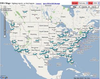
You can now view UFO sightings with Google Maps or MSN Virtual Earth. Poly9, a web development company, created UFO Maps. It allows you to view the locations of the sighting and link to the report. Check it out at http://www.ufomaps.com/.

Thursday, March 16, 2006

GIScareers

Hi! We have a retirement party this morning for our GIS Crime Analyst. Best wishes Marsha as you write another chapter with your move to California. I also have a meeting with our street sign guys to discuss how they use Cartegraph for sign inventory. If you have experience (good or bad) with Cartegraph I would love to hear about it. I'm on the road tomorrow so you won't see a post. We have a South Central Arc User Group planning committee meeting in Dallas. Have a great St. Paddy's Day!!

"GIScareers.com contains GIS job advertisements and resumes for Geographic Information Systems and Geography related positions. Other areas covered are remote sensing, mapping and cartography, forestry, spatial analysis and many more." What's great is that they not only cover the U.S., but other countries. In case you are looking to move to Djibouti. Check it out at http://giscareers.com/.

Wednesday, March 15, 2006

The Ontario Beer Hunter *

Good day! Big news from the GISUser this morning. Arc2Earth has been officially released. This is the software that lets you easily convert your ESRI data into Google Earth data. Also, Sketchup (@Last software) was purchased by Google. For those that aren't familiar Sketchup is an awesome tool that lets you easily create 3D scenes. They also offer an extension for ArcGIS to bring your GIS data into Sketchup and vice versa. Today I have my quarterly GIS Executive Committee meeting. This is the group that helps steer our GIS program here at the City. It's a great idea if you don't already have one because it allows the stakeholder departments to provide feedback. Have a good one!

The Ontario Beer Hunter (*Not to be confused with this beer hunter) is a great Google mashup that shows where to find beer in Ontatrio, Canada. What an excellent idea!! The creator has come up with unique icons for different establishments and he invites you to submit missing locations. You can search by city or by region. He also shows the stores operating hours by using semi-transparent icons to indicate stores that are closed. Awesome!! I'm ready for this site to go worldwide. Check it out at http://www.beerhunter.ca/.

Tuesday, March 14, 2006

MidAmerica GIS Consortium

This is my 100th post on the Geoblog!!! It sure doesn't seem like I have posted that many times. I'll keep it up as long as a few people keep reading. I have a meeting today with our economic development coorporation. This is a sector where GIS can really be of benefit. It has taken off in many areas, but it has a long way to go. We are going to talk with them about what data we can provide and possibly some training for them.

"The MidAmerica GIS Consortium, Ltd. (MAGIC) is a nonprofit educational organization established to foster the applications of geographic information systems (GIS) and related spatial technologies in the mid-continent region. The Consortium sponsors a biennial MidAmerica GIS Symposium in even numbered years. MAGIC provides a focus for:
Establishing linkages between GIS users having similar application interests; Facilitating communication and data sharing across levels of government and between government, industry and academia; Promoting spatial data standards and land records modernization;
Promoting collaboration and advancement of geospatial technologies in government. MAGIC states include, but are not limited to: Arkansas, Iowa, Kansas, Missouri, Nebraska, North Dakota, Oklahoma & South Dakota." Learn more at http://magicweb.kgs.ku.edu/.

Monday, March 13, 2006

worldkit

Happy Birthday Sweetheart!! I hope you have a wonderful day. For those of you that I don't call sweetheart that is for my girlfriend. I know she reads my blog first thing in the morning so I wanted to get that in early. The garage sale didn't pan out like I had hoped this weekend. We got full on sushi and sake Friday night celebrating her birthday and decided to make a spur of the moment trip to Shreveport to gamble. Therefore the garage sale didn't happen Saturday morning. You only live once!!!

"worldKit is an easy to use and flexible mapping application for the Web. Light weight GIS. It's a SWF based app, configured by XML, data fed by RSS. Stand-alone use or integration in larger projects. Features include ... Ubiquitous use in the Flash Player and with RSS feeds; Highly configurable look and feel; Can use images for marking annotations; Integrates with weblogging tools, and any software producing RSS; Annotations updated in the background, live; Displays photos within the map; Zoom & Pan. Integrates with Zoomify for high resolution images; Accepts input for Collaborative Cartography; Annotations are categorizable; Javascript interface for GIS layer functionality; Connects annotations for GPS track routes." Check it out at http://worldkit.org/index.php. Enjoy!

Friday, March 10, 2006

Mapserver

Hi! The ETUG meeting went well. We had over 30 attendees and the networking was good. Now I need to start thinking about the next meeting. This weekend I will be working on packing and a garage sale. What fun! Ha! Have a good weekend.

"MapServer is an Open Source development environment for building spatially-enabled internet applications. MapServer is not a full-featured GIS system, nor does it aspire to be. Instead, MapServer excels at rendering spatial data (maps, images, and vector data) for the web.
Beyond browsing GIS data, MapServer allows you create "geographic image maps", that is, maps that can direct users to content. For example, the Minnesota DNR Recreation Compass provides users with more than 10,000 web pages, reports and maps via a single application. The same application serves as a "map engine" for other portions of the site, providing spatial context where needed. MapServer was originally developed by the University of Minnesota (UMN) ForNet project in cooperation with NASA and the Minnesota Department of Natural Resources (MNDNR). Presently, the MapServer project is hosted by the TerraSIP project, a NASA sponsored project between the UMN and consortium of land management interests. The software is maintained by a growing number of developers (nearing 20) from around the world and is supported by a diverse group of organizations that fund enhancements and maintenance." Check it out at http://mapserver.gis.umn.edu/.

Thursday, March 09, 2006

Housing Maps

Good day! The ETUG meeting is today and I have much to do. It is a little nerve racking sense it is my first as the president. Cross your fingers that all goes well.

Housing Maps uses both Craigslist and GoogleMaps to create a great mashup. You can search houses that are For Rent, For Sale, Rooms, and Sublets. You can also search based on City, Price, Number of Rooms, Pictures, Dogs or Cats. The creator says that "Safari & Opera support is coming soon and more cities are on their way". Although the site already has a ton of cities to choose from. Check it out at www.housingmaps.com.

Wednesday, March 08, 2006

Google Earth Hacks

Hola! Another day of meetings and preparation for meetings. Our first meeting of the year for the East Texas GIS & GPS User Group (ETUG) is tomorrow. If you are from the East Texas or Western Louisianna area please join us.

If you already have Google Earth, Google Earth Hacks will give you files to enhance your experience with Google Earth. If you don't have Google Earth you are missing out on the fun. "Some of the files will simply point out fun places to visit, while others can do things like put real-time weather radars on your map, add in more 3D buildings, or any number of other things. The easiest way to use the files is to have Google Earth already open while you're viewing our site. When you find a file you want, just click the "download" link. If your browser gives you the choice, choose to just open the file. Wait a few seconds and your computer should switch over to Google Earth and fly you to the new location! If you choose to save the file to your disk, just locate it and double-click on it to get Google Earth to open it and fly you there. KMZ and KML are the formats that Google Earth uses to store information about locations on the map. If you ever add a placemark to the map (by going to [Add] and then [Placemark]), you can save that file as a KMZ and share it with the world! This site has nothing to do with illegal hacking that you read about in the news. The "hacks" on here simply refer to files that you can download to enhance your use of Google Earth. Hacks often refer to add-on software for a program." Check it out at www.googleearthhacks.com.

Tuesday, March 07, 2006

Green Map System

Good Morning! Not much news to report here other than the work in flowing in at a rapid rate. Oh well, I guess it means we are needed. Better than the opposite.

"The Green Map System (GMS) is a locally adaptable, globally shared framework for environmental mapmaking. It invites design teams of all ages and backgrounds to illuminate the connections between natural and human environments by mapping their local urban or rural community. Using GMS's shared visual language--a collaboratively designed set of Icons representing the different kinds of green sites and cultural resources--Mapmakers are independently producing unique, regionally flavored images that fulfill local needs, yet are globally connected. The resulting Green Maps identify, promote and link eco and cultural resources. Merging the ancient art of map making with new media tools, each of these maps creates a fresh perspective that helps residents discover and get involved in their community's environment, and helps guide tourists (even virtual ones) to special places and successful green initiatives they can replicate back home." Check it out at www.greenmap.org.

Monday, March 06, 2006

Ask.com

Happy Monday! Latino night on Friday was a good time and I even learned how to salsa (kinda). The rest of my weekend consisted of packing and sleep. We have too much junk. Hopefully with a garage sale this weekend we can get rid of some of it. Anyway, back to the grind!

Ask.com has brought mapping to their website. Some of the features include draggable maps (click and drag the map to move around), multipoint directions (find directions for up to 10 places at once), dynamic locations (add, move, and re-order your locations using your mouse), auto-drive (watch an animation of your entire route before you set out on your trip), and keyboard support (for faster navigation). Check it out at http://www.ask.com/?o=312#subject:map.

Friday, March 03, 2006

Podbop

It's Friday!! Many changes are coming in my life in the next month....we start packing this weekend for a move to Longview, TX to be closer to work. My girlfriend is also preparing to go to Mexico for three months this summer. Other than those not so minor changes things are the same. We are planning on going to "Latino night" at a local club tonight. We just can't get enough of that Latin flavor! Also, check out the pictures of Mexico at the bottom of the page that I added to my Frappr site.

Podbop is let's you search for bands that are coming to a certain city, listen to their MP3's, find a band you like and go see them. The old way consisted of "looking up concerts in your town on an event site, googling 100 different bands, tracking down an MP3 for each band, and then deciding which show you want to go to." So what does this have to do with mapping? They use John Emerson's DIY Map. This allows you to click on recently searched cities and see the bands coming to that area. Check it out at http://podbop.org/.

Thursday, March 02, 2006

Windows Live Local "Street-Side" Preview

Good morning! I think I have actually caught up on some sleep. Vacation can really wear you out sometimes. It's back to the grind with meetings and preparation for more meetings.

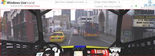
Windows Live Local has provided a preview into their new "street-side" views. "Technology Preview demonstrates their work-in-progress thinking about a rich immersive experience in mapping that also explores local information. Historically, maps give you a perspective of geographical information about a place. In Windows Live™ Local, powered by Virtual Earth™, you’ve seen road, aerial, and hybrid maps. Then, we introduced bird's eye views to give you a perspective from above. Now, we want you to be there, right in front of the pizza shop you are searching for, in the street-side views offered by Windows Live Local. Even though you haven’t left the comfort of your computer chair, you’ll feel like you’re actually there. Street-side views enables you to view imagery as if you were driving or walking along the street. There are a number of ways to explore street-side views. You can explore street-side views by "driving" (with your mouse or with the arrow keys on your keyboard) our "Sports Car" or "Race Car" along streets in the map or you can also "Walk" along the street. When the car is on a street that has street-side images, the car headlights turn on and you can view the front, right, and left views through the car windows above." So far the preview only includes Seattle and San Francisco. Check it out at http://preview.local.live.com/.

Wednesday, March 01, 2006

Cyber-Geography Research

I'm back!! The trip to Mexico was incredible. We should all get a chance to spend the weekend in the jungle. I hope to get some photos on my Flickr site soon. I'll tell more soon, but I have much to catch up on.

"CyberGeography is the study of the spatial nature of computer communications networks, particularly the Internet, the World-Wide Web and other electronic "places" that exist behind our computer screens, popularly referred to as cyberspace. Cybergeography encompasses a wide range of geographical phenomena from the study of the physical infrastructure, traffic flows, the demographics of the new cyberspace communities, to the perception and visualisation of these new digital spaces. In addition, the potential geographical impacts of Cyberspace technologies on real-space needs to be examined. There are many geographies of cyberspace and many geographical approaches to study them. The emphasis of Cyber-Geography Research tends to be on the more quantitative aspects of measuring and mapping the geography of cyberspaces." Learn more at http://www.cybergeography.org/.

Planet Geospatial

ESRI.com - News

GISUser.com - The complete GIS, LBS, and Geospatial Technology Resource

A VerySpatial Podcast